
Photo by caleb weiner on Unsplash

Photo by Linhao Zhang on Unsplash

Photo by Jay Chapman on Unsplash

Photo by Steve Wrzeszczynski on Unsplash
8 Days: Broken Arrow to Sherman via the Black Hills
This 8-day road trip carries travelers from Broken Arrow, Oklahoma north through the Kansas prairie and Nebraska's Pine Ridge country before diving into South Dakota's Badlands and the Black Hills. Along the way, the route passes iconic stops including Monument Rocks, Scotts Bluff National Monument, Badlands National Park, Mount Rushmore, Custer State Park, the Needles Highway, Crazy Horse Memorial, Spearfish Canyon, Devils Tower in Wyoming, and the historic gold rush town of Deadwood. The journey wraps up with a heritage loop through Sturgis and Rapid City before the long drive home to Sherman, SD, with stops at the Mitchell Corn Palace and Sioux Falls. Easy driving and sightseeing throughout make this a relaxed, scenic itinerary suited to a comfortable 4x4 SUV.
Built stop by stop, not written as an article.
Xavier starts with this location and helps you build your own version of the trip.
- Days
- 8
- Stops
- 46
- Driving
- 1,327 mi
- Overnights
- 8
- Level
- easy
Published by Xploreum · August 2026
ARE YOU XPLORER MATERIAL?
The average Xplorer every year...
Sleeps outside 24 nights
Explores 1,800 miles
Covers 500 miles on foot, skis, bikes, boats and trails
Experiences a 120°F temperature difference
Discovers 18 new places
Does something for the first time 18 times
Sees the Milky Way 11 nights
Takes 6 people on their first adventure
Spends 240 hours away from notifications
Creates stories remembered for decades
The shape of it
How the route moves
8 days and 46 stops, covering 1,327 mi of driving. Every distance comes from the route records behind this Xpedition.
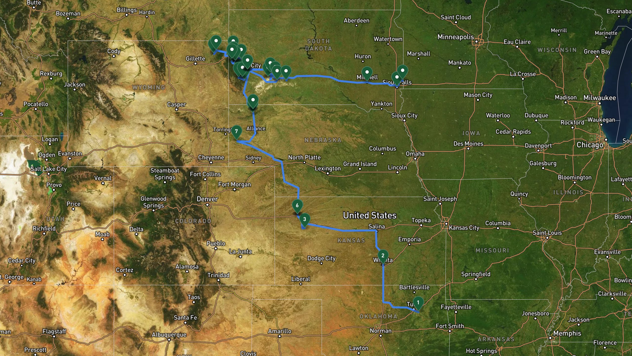
Route overview, not navigation
Stops are shown at place level. Each leg is coloured by the travel mode we infer from the stops at either end, then drawn along that network: blue for driving. The mode is our inference, not a confirmed record of how the route was travelled. A grey dashed leg is one we could not route, shown as a straight overview instead. This is an overview of the route, not a turn-by-turn track, and it is not suitable for navigation.
The itinerary
Day by day
All 46 stops, free to read. Every day is editable once the route is yours.

Photo by Mick Haupt on Unsplash
Into the Kansas Prairie
- 392 mi drive
- Night: Colby, KS area hotel accommodation
The trip begins in the Broken Arrow, Oklahoma area, heading north on US-75 and US-166 into Kansas. A stop in Wichita, Kansas' largest city, offers coffee and a stretch in the historic Old Town district. Continuing northwest, the route reaches Monument Rocks, striking 70-foot chalk formations rising from the prairie and estimated to be more than 80 million years old. The day wraps up in Colby, Kansas, a small plains town for fuel, dinner, and an overnight stay at a comfortable hotel with breakfast included.
Broken Arrow, OKDrive
Departure from Broken Arrow area. Head north on US-75 and US-166 toward Kansas.
+137 mi along the route
Wichita, KSDrive
Stop in Kansas' largest city for coffee and a stretch. Historic Old Town district.
+199 mi along the route
Monument RocksViewpoint
Stunning 70-foot chalk formations rising from the prairie, over 80 million years old.
+55.9 mi along the route
Colby, KSDrive
Small Kansas plains town, fuel and dinner stop.
+0.6 mi along the route
Hotel in Colby, KSlodge
Clean, comfortable hotel accommodation with breakfast included.

Photo by Ryan Grewell on Unsplash
The Oregon Trail North
- 190 mi drive
- Night: Chadron, NE area hotel accommodation
Departing Colby, the route follows I-70 and US-385 northwest into Nebraska. The highlight is Scotts Bluff National Monument, an 800-foot bluff that once guided Oregon Trail pioneers, with a summit drive offering sweeping prairie views. The road continues to Chadron State Park, Nebraska's oldest state park, tucked into the Pine Ridge with scenic drives through ponderosa pine forest. The day ends in Chadron, a historic cattle town at the edge of the Pine Ridge, with dinner and an overnight hotel stay including free breakfast.
Colby, KSlodge
Morning departure from Colby. Head northwest on I-70 to US-385.
+180 mi along the route
Scotts Bluff National MonumentViewpoint
Towering 800-foot bluff that guided Oregon Trail pioneers. Summit drive offers panoramic prairie views.
+87 mi along the route
Chadron State ParkViewpoint
Nebraska's oldest state park, nestled in the Pine Ridge. Scenic drives through ponderosa pine forest.
+9.3 mi along the route
Chadron, NEDrive
Historic cattle town at the edge of the Pine Ridge. Dinner stop.
+0.6 mi along the route
Hotel in Chadron, NElodge
Comfortable hotel with free breakfast.

Photo by Dave Hoefler on Unsplash
Into the Badlands
- 109 mi drive
- Night: Badlands area hotel accommodation
Leaving Chadron, the drive heads east on US-20 and north on SD-240 into the heart of the Badlands. Entering Badlands National Park through the northeast entrance, travelers cover the 30-mile Badlands Loop Road, stopping at overlooks, fossil exhibits, and dramatic layered rock formations. A stop at Wall Drug Store brings free ice water, a giant jackalope, and an Old West shopping arcade. The route then visits the Minuteman Missile National Historic Site, a preserved Cold War-era missile silo and launch control facility. The night is spent in Interior, South Dakota, at a comfortable hotel with an on-site restaurant.
Chadron, NElodge
Morning departure from Chadron. Head east on US-20 then north on SD-240 into the Badlands.
+80.8 mi along the route
Badlands National Park - Northeast EntranceDrive
Enter Badlands National Park via the northeast entrance. 7-day vehicle pass.
Badlands Loop Road Scenic DriveDrive
Drive the 30-mile Badlands Loop Road with stops at overlooks, fossil exhibits, and layered rock formations.
+12.4 mi along the route
Wall Drug Storeactivity
Legendary South Dakota roadside attraction with free ice water, giant jackalope, and Old West shopping arcade.
+21.7 mi along the route
Minuteman Missile National Historic SiteViewpoint
Cold War-era missile silo and launch control facility, now a National Historic Site.
+15.5 mi along the route
Hotel in Interior, SDlodge
Comfortable hotel in the Badlands area with restaurant.

Photo by Jack Hishmeh on Unsplash
Rushmore and the Black Hills
- 127 mi drive
- Night: Hill City, SD area hotel accommodation
From Interior, SD-44 leads west into the Black Hills. The centerpiece of the day is Mount Rushmore National Memorial, with its 60-foot carved presidential faces of Washington, Jefferson, Roosevelt, and Lincoln. From there, the Wildlife Loop Road through Custer State Park's 71,000 acres offers chances to spot bison, pronghorn, and burros among rolling prairie and granite spires. The Needles Highway follows, a 14-mile scenic byway winding through towering granite spires and narrow rock tunnels. The day concludes in Hill City, a charming mountain town with galleries, shops, and cafes, with an overnight stay at a retro roadside hotel.
Interior, SDlodge
Morning departure from Interior. Head west on SD-44 into the Black Hills.
+90.1 mi along the route
Mount Rushmore National MemorialViewpoint
Iconic 60-foot carved presidential faces of Washington, Jefferson, Roosevelt, and Lincoln in granite.
+11.2 mi along the route
Custer State ParkDrive
Scenic Wildlife Loop Road through 71,000 acres of rolling prairie and granite spires. Bison, pronghorn, burros.
+15.5 mi along the route
Needles HighwayDrive
Stunning 14-mile scenic byway through towering granite spires and narrow tunnels carved into rock.
+9.3 mi along the route
Hill CityDrive
Charming mountain town with galleries, shops, and cafes. Dinner stop.
+0.6 mi along the route
Hotel in Hill City, SDlodge
Retro roadside hotel with comfortable rooms.

Photo by Heath Hughes on Unsplash
Monuments and the Northern Hills
- 79.5 mi drive
- Night: Deadwood, SD area hotel accommodation
Heading south from Hill City on US-385 and US-16, the route arrives at the Crazy Horse Memorial, a massive mountain carving in progress honoring the Lakota warrior, with a visitor complex featuring a museum and cultural exhibits. Iron Mountain Road follows, a 17-mile scenic byway known for pigtail bridges and tunnels that frame Mount Rushmore. The drive then continues to the Spearfish Canyon Scenic Byway, a 20-mile route past limestone cliffs and waterfalls along Spearfish Creek. The day ends in Historic Downtown Deadwood, a famous Wild West gold rush town with casinos, saloons, and Mount Moriah Cemetery, with lodging at a modern hotel and casino in the heart of town.
Hill City, SDlodge
Morning departure from Hill City. Head south on US-385 and US-16 toward Crazy Horse.
+8.7 mi along the route
Crazy Horse MemorialViewpoint
Massive mountain carving in progress honoring Lakota warrior Crazy Horse. Visitor complex with museum and cultural exhibits.
+12.4 mi along the route
Iron Mountain RoadDrive
17-mile scenic byway with pigtail bridges, tunnels framing Mt. Rushmore, and stunning Black Hills vistas.
+46.6 mi along the route
Spearfish Canyon Scenic BywayDrive
Gorgeous 20-mile drive through limestone cliffs, waterfalls, and autumn color along Spearfish Creek.
+11.2 mi along the route
Historic Downtown Deadwoodactivity
Famous Wild West gold rush town with casinos, historic saloons, and Mount Moriah Cemetery.
+0.6 mi along the route
Hotel in Deadwood, SDlodge
Modern hotel and casino in the heart of historic Deadwood with restaurants and entertainment.

Photo by aarsh mathur on Unsplash
Devils Tower and Wyoming Wilds
- 165 mi drive
- Night: Spearfish, SD area hotel accommodation
From Deadwood, US-85 leads north into Wyoming. A quick photo and coffee stop at Belle Fourche marks the Center of the Nation monument, the geographic center of the United States. The route continues to Devils Tower National Monument, America's first national monument, an 867-foot volcanic rock formation sacred to Native tribes. Lunch is taken in Hulett, a tiny Wyoming ranching town with Old West charm. The day finishes in Spearfish, a gateway town to the northern Black Hills, with a comfortable hotel stay including breakfast.
Deadwood, SDlodge
Morning departure from Deadwood. Head north on US-85 into Wyoming toward Devils Tower.
+34.2 mi along the route
Belle FourcheDrive
Center of the Nation monument marking the geographic center of the United States. Quick photo stop and coffee.
+59 mi along the route
Devils Tower National MonumentViewpoint
America's first national monument, a stunning 867-foot volcanic rock formation sacred to Native tribes.
+11.2 mi along the route
HulettDrive
Tiny Wyoming ranching town with Old West charm. Lunch stop.
+59 mi along the route
SpearfishDrive
Gateway to the northern Black Hills with downtown shops and dining.
+1.9 mi along the route
Hotel in Spearfish, SDlodge
Comfortable hotel with breakfast included and easy highway access.

Photo by Travis Brown on Unsplash
Black Hills Heritage Loop
- 80.8 mi drive
- Night: Rapid City, SD area hotel accommodation
Leaving Spearfish on I-90, the route heads toward Sturgis, home to the Sturgis Motorcycle Museum, celebrating motorcycle history and the world's largest motorcycle rally. Next is the Sanford Lab Homestake Visitor Center, a former gold mine turned underground science laboratory with surface tours and exhibits. A short nature trail leads to Roughlock Falls, a scenic waterfall in Spearfish Canyon reached via an easy 0.9-mile walk. The day ends in Downtown Rapid City, where Art Alley and the City of Presidents statues line the streets, with an overnight stay at a historic landmark hotel downtown.
Spearfish, SDlodge
Morning departure from Spearfish. Head east on I-90 toward Sturgis and Lead.
+24.9 mi along the route
Sturgis Motorcycle Museumactivity
Museum dedicated to motorcycle history and the legendary Sturgis Rally, the world's largest motorcycle event.
+21.7 mi along the route
Sanford Lab Homestake Visitor CenterViewpoint
Former gold mine now a deep underground science laboratory. Surface tours and exhibits on mining history and physics research.
+13.7 mi along the route
Roughlock FallsViewpoint
Beautiful waterfall in Spearfish Canyon accessible via easy 0.9-mile nature trail through forest.
+52.8 mi along the route
Rapid City DowntownDrive
Downtown Rapid City with Art Alley, City of Presidents statues on street corners, and dining.
+3.1 mi along the route
Rapid City DowntownDrive
Downtown Rapid City with Art Alley, City of Presidents statues on street corners, and dining.
Hotel in Rapid City, SDlodge
Historic landmark hotel in the heart of downtown Rapid City with regional architecture.

Photo by Jay Chapman on Unsplash
The Long Road Home
- 183 mi drive
- Night: Sherman, SD
The final day departs Rapid City heading east on I-90. A stop at the Badlands National Park east entrance offers one last look at the formations from a different angle. The route continues to Mitchell, home of the world-famous Corn Palace, decorated with murals made entirely from corn and grain and redesigned annually. A stop in Sioux Falls, South Dakota's largest city, allows time for coffee and a stretch near Falls Park's scenic waterfalls and historic ruins. The journey concludes with arrival in Sherman, SD, marking the end of the trip.
Rapid City, SDlodge
Morning departure from Rapid City. Head east on I-90 toward Sherman.
+90.1 mi along the route
Badlands National Park East EntranceViewpoint
Re-enter Badlands from the east for a different perspective. Final photo stop in the formations.
+137 mi along the route
Mitchell Corn Palaceactivity
World-famous building decorated with murals made entirely from corn and grain, redesigned annually.
+71.5 mi along the route
Sioux FallsDrive
South Dakota's largest city. Falls Park has scenic waterfalls and historic ruins. Coffee and stretch stop.
+21.7 mi along the route
Sherman, SDDrive
Arrival in Sherman, SD. Trip complete.
8 days does not quite fit?
Take this route as your starting point and reshape it around your dates, your pace, and the stops you care about most.
WHAT XPLORERS ARE SAYING
I discovered Xploreum yesterday while searching for an app to plan a road trip to Newfoundland and Labrador. The conversational approach allows us to pinpoint exactly our needs and expectations and build an ideal itinerary. Highly recommended!
I took a look at the program and found it quite cool to use. I did not give it a lot of prompts and it gave me a really neat place to hike in my home state. I think it works really well.
I’m sitting and planning summer vacation trips. This year, Christian and I are going on a road trip, most likely to Eastern Europe. That also gives me a reason to tell you about this insanely cool AI model. Xploreum.io has developed a model that can help you find the coolest places that aren’t touristy, and it can actually put together an entire trip for you. It’s insanely smart. Not an ad. Just a genuine recommendation.
Before you go
What this route assumes
Only the fields this route actually holds data for.
Where you sleep
Overnight areas in route order: Colby, KS area hotel accommodation, Chadron, NE area hotel accommodation, Badlands area hotel accommodation, Hill City, SD area hotel accommodation, Deadwood, SD area hotel accommodation, Spearfish, SD area hotel accommodation, Rapid City, SD area hotel accommodation, Sherman, SD. Xavier pairs each with live lodging options once the route is yours.
Vehicle
Built as a 4x4 suv route, scenic driving and sightseeing. Xavier adapts it to what you actually drive.
Level
Paced for easy travelers. Days can be split or merged to change the load.
How this Xpedition was built
Assembled from structured route and waypoint records, not written as an article, and reviewed before publication. Confirm conditions, closures, and permits before you travel.
- Route structured
- Distances calculated
- Reviewed before publication
- Published August 2026
More Xpeditions
See all
5-Day Itinerary: NYC to Niagara Falls, Ontario
This 5-day trip flies from the southern USA into New York City for a night of sightseeing and Broadway, takes the train to Buffalo, then drives into Niagara Falls, Ontario for two full days of gorge hikes, waterfall tours, wine country, and maple syrup tasting before returning home.
Major Airport - Southern USANiagara Falls Canada AccommodationHome
5 days3,751 km driving47 stopsmoderate

3-Day Road Trip Itinerary: Merrimack, NH to Cody, WY
This 3-day drive covers roughly 1,975 miles from Merrimack, New Hampshire to Cody, Wyoming, with overnight stops in South Bend, Indiana and Custer, South Dakota, taking in the Badlands, Custer State Park, and the Bighorn Mountains along the way.
Departure location, Merrimack NH areaFairfield Inn & Suites South Bend, IN area overnight stay (South Bend)The Cody Hotel, Cody WY overnight stay (Cody area)Hotel, Cody area
3 days2,244 mi driving15 stopseasy

Anniversary Drive to Coastal Maine: 5-Day Camden Road Trip Itinerary
A 5-day scenic road trip from Daytona Beach to Camden, Maine, featuring fall foliage hikes in Connecticut, coastal harbor towns, Acadia National Park, and boutique lodging for a romantic anniversary getaway.
Daytona Beach DepartureFamily Home, New Jersey area.Home, Daytona Beach, Florida area.Daytona Beach
5 days3,080 mi driving28 stopsmoderate
Make this Xpedition yours.
Dates, pace, lodging, vehicle, and who is coming can all be rebuilt around you, starting from this exact route: 8 Days: Broken Arrow to Sherman via the Black Hills.
You keep
- The full 8 day route, editable day by day
- Distances and pacing recalculated around you
- One conversation to change anything