
Photo by Chris Leipelt on Unsplash


Photo by Seungho Park-Lee on Unsplash

Photo by Nina Perminova on Unsplash
7 Days in Yellowstone: A Wyoming Road Trip Itinerary
This 7 day itinerary explores Yellowstone National Park by 4x4 SUV, mixing moderate hikes, wildlife viewing, and scenic drives. The route begins with a long drive west from the Gretna area of Nebraska to West Yellowstone, then bases at Madison Campground to explore Grand Prismatic Spring, Old Faithful, and Mystic Falls. From there the trip heads north to Mammoth Hot Springs and Bunsen Peak before overnighting in Gardiner, Montana. The middle days focus on wildlife safaris through Lamar Valley and Hayden Valley, the Grand Canyon of the Yellowstone at Artist Point, and the thermal features of West Thumb Geyser Basin along Yellowstone Lake, with two nights at Canyon Village Campground. The trip continues south past Yellowstone Lake to Flagg Ranch Campground near the John D. Rockefeller Memorial Parkway, and closes with a scenic loop through Grand Teton National Park visiting Oxbow Bend, Signal Mountain, Jenny Lake, Mormon Row, and the town of Jackson before returning to Flagg Ranch for the final night.
Built stop by stop, not written as an article.
Xavier starts with this location and helps you build your own version of the trip.
- Days
- 7
- Stops
- 54
- Driving
- 1,208 mi
- On foot
- 53.9 mi
- Overnights
- 4
- Level
- moderate
Published by Xploreum · August 2026
ARE YOU XPLORER MATERIAL?
The average Xplorer every year...
Sleeps outside 24 nights
Explores 1,800 miles
Covers 500 miles on foot, skis, bikes, boats and trails
Experiences a 120°F temperature difference
Discovers 18 new places
Does something for the first time 18 times
Sees the Milky Way 11 nights
Takes 6 people on their first adventure
Spends 240 hours away from notifications
Creates stories remembered for decades
The shape of it
How the route moves
7 days and 54 stops, covering 1,208 mi of driving, 53.9 mi on foot. Every distance comes from the route records behind this Xpedition.
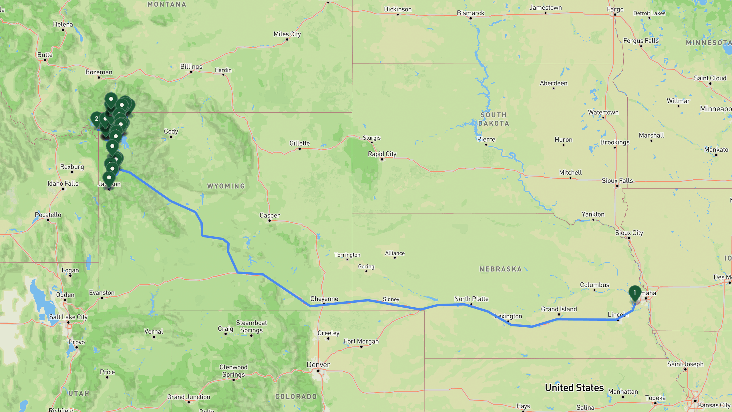
Route overview, not navigation
Stops are shown at place level. Each leg is coloured by the travel mode we infer from the stops at either end, then drawn along that network: blue for driving and magenta for walking. The mode is our inference, not a confirmed record of how the route was travelled. A grey dashed leg is one we could not route, shown as a straight overview instead. This is an overview of the route, not a turn-by-turn track, and it is not suitable for navigation.
The itinerary
Day by day
All 54 stops, free to read. Every day is editable once the route is yours.

Photo by Benjamin Klaver on Unsplash
The Long Road West
- 813 mi drive
- Night: Madison Campground, Yellowstone National Park, Wyoming
The trip begins with departure from the Gretna area of Nebraska, heading west on the interstate toward Yellowstone. This is a long driving day of roughly 800 miles, ending at the gateway town of West Yellowstone, where you can pick up park information, maps, and any last supplies before entering the park. From there it is a short 14 mile drive to Madison Campground, set along the Madison River, which serves as home base for exploring the western geyser basins. The campground offers 278 sites with flush toilets and potable water.
Gretna area, NebraskaDrive
Departure from the Gretna area in Nebraska. Load up the SUV and head west on I-80.
+800 mi along the route
West Yellowstone areaDrive
Gateway town to Yellowstone's west entrance. Stop for park information, maps, and final supplies.
+13.7 mi along the route
Madison Campgroundlodge
Yellowstone campground along the Madison River. 278 sites with flush toilets and potable water. Base camp for exploring the western geyser basins.

Geysers and Rainbows
- 47.8 mi drive
- 7 mi on foot
- Night: Madison Campground, Yellowstone National Park, Wyoming
Start the day with a steep but short 0.8 mile climb to the Grand Prismatic Spring Overlook, gaining about 200 feet in elevation for a sweeping view over the park's most vividly colored thermal pool. From there, drive south to Old Faithful Geyser, where eruptions send water 130 to 180 feet into the air roughly every 60 to 110 minutes. Take time to walk the boardwalks of the Upper Geyser Basin, and grab a meal at a historic lodge restaurant nearby known for hearty American fare and scenic views. In the afternoon, head to the Biscuit Basin Trailhead for the hike to Mystic Falls, a 2.4 mile round trip gaining about 350 feet to reach a 70 foot waterfall cascading over columnar basalt. Return to Madison Campground for the night to relax along the river.
Grand Prismatic Spring Overlook TrailheadDrive
Trailhead for the overlook hike above Yellowstone's most iconic thermal feature.
+1 mi along the route
Grand Prismatic Spring OverlookHike
Steep 0.8-mile climb to elevated viewpoint over the vivid blue and orange pool. 200 feet elevation gain.
+1 mi along the route
Grand Prismatic Spring Overlook TrailheadDrive
Return to trailhead and drive south to Old Faithful.
+6.8 mi along the route
Old Faithful Geyseractivity
Watch the world's most famous geyser erupt 130-180 feet high. Eruptions every 60-110 minutes. Walk the Upper Geyser Basin boardwalks.
+0.3 mi along the route
Old Faithful area diningmeal
Dining at a historic lodge restaurant with hearty American fare and scenic views.
+3.4 mi along the route
Biscuit Basin TrailheadDrive
Trailhead for Mystic Falls, a beautiful waterfall and thermal area hike.
+2.5 mi along the route
Mystic FallsHike
2.4-mile round trip to 70-foot waterfall cascading over columnar basalt. 350 feet elevation gain.
+2.5 mi along the route
Biscuit Basin TrailheadDrive
Return to trailhead and head back to Madison Campground.
+13.7 mi along the route
Madison Campgroundlodge
Return to Madison Campground for the night. Cook dinner and relax by the Madison River.

Photo by Laura Seaman on Unsplash
North to the Terraces
- 49.6 mi drive
- 8.5 mi on foot
- Night: Yellowstone area RV Park, Gardiner, Montana
After breaking camp at Madison, drive north to Norris Geyser Basin, Yellowstone's hottest and most dynamic thermal area, and walk the Porcelain Basin and Back Basin boardwalk loops covering about 2.5 miles combined. Continue on to Mammoth Hot Springs to see the massive travertine terraces, walking both the Upper and Lower Terrace loops, and stop for lunch at a historic hotel overlooking the parade ground. In the afternoon, tackle the Bunsen Peak hike, a 4.2 mile round trip climbing about 1,300 feet to an 8,564 foot summit with panoramic views of the Gallatin Range, Mammoth, and Swan Lake Flats. The night is spent at a full-service campground in Gardiner, Montana, just north of the park entrance, with showers, laundry, and WiFi available.
Madison Campgroundlodge
Wake up at Madison Campground. Pack up and prepare for a northbound tour to Mammoth.
+14.3 mi along the route
Norris Geyser Basinactivity
Yellowstone's hottest and most dynamic thermal area. Walk Porcelain Basin and Back Basin boardwalk loops, approximately 2.5 miles total.
+21.1 mi along the route
Mammoth Hot Springs TerracesDrive
Massive travertine terraces built by hot spring mineral deposits. Walk Upper and Lower Terrace loops.
+0.5 mi along the route
Mammoth Hot Springs area diningmeal
Lunch at a historic hotel with views of the parade ground.
+5 mi along the route
Bunsen Peak TrailheadDrive
Trailhead for Bunsen Peak hike with panoramic Yellowstone views.
+4.2 mi along the route
Bunsen Peak SummitHike
4.2-mile round trip to 8,564-foot summit. 1,300 feet elevation gain with sweeping views of the Gallatin Range, Mammoth, and Swan Lake Flats.
+4.2 mi along the route
Bunsen Peak TrailheadDrive
Return to trailhead and drive to Gardiner for the night.
+8.7 mi along the route
Campground in Gardiner arealodge
Full-service campground in Gardiner, Montana, just north of the park entrance. Sites for tents and RVs with showers, laundry, and WiFi.

Photo by Dustin Commer on Unsplash
Lamar Valley Wildlife Safari
- 80.8 mi drive
- 8 mi on foot
- Night: Canyon Village Campground, Yellowstone National Park, Wyoming
Rise early for a dawn wildlife drive through Lamar Valley, often described as the Serengeti of North America, watching for bison herds, grizzlies, wolves, elk, and pronghorn. Continue to the Slough Creek Trailhead, reached via a gravel access road, for a 4 mile round trip hike through wildflower meadows along Slough Creek, a wildlife-rich corridor favored by elk and grizzlies with minimal elevation gain. Head west toward Tower Junction to see Tower Fall, a 132 foot waterfall plunging into the Yellowstone River canyon, reached by a short paved trail. Enjoy rustic lodge dining nearby with regional fare like BBQ ribs, bison chili, and cornbread, then continue to Canyon Village Campground for the night, a large campground with 273 sites, showers, laundry, and a camp store.
Gardiner area campgroundlodge
Early wake-up for wildlife viewing in Lamar Valley. Pack breakfast to go.
+39.8 mi along the route
Lamar Valleyactivity
The Serengeti of North America. Drive slowly through the valley spotting bison herds, grizzlies, wolves, elk, and pronghorn at dawn.
+7.5 mi along the route
Slough Creek TrailheadDrive
Trailhead for Slough Creek meadows hike. Gravel access road from Northeast Entrance Road.
+4 mi along the route
Slough Creek First MeadowHike
4-mile round trip through wildflower meadows along Slough Creek. Minimal elevation gain, wildlife-rich corridor favored by elk and grizzlies.
+4 mi along the route
Slough Creek TrailheadDrive
Return to trailhead and drive west toward Tower Junction.
+11.2 mi along the route
Tower Fallactivity
132-foot waterfall plunging into the Yellowstone River canyon. Short paved trail to overlook.
+3.1 mi along the route
Roosevelt Lodge area diningmeal
Rustic lodge dining with regional fare including BBQ ribs, bison chili, and cornbread.
+19.3 mi along the route
Canyon Village Campgroundlodge
Large campground near the Grand Canyon of the Yellowstone. 273 sites with showers, laundry, and camp store.

Canyon, Valley, and Lakeshore
- 49.1 mi drive
- 30.6 mi on foot
- Night: Canyon Village Campground, Yellowstone National Park, Wyoming
Begin at Artist Point for the best morning light over the 308 foot Lower Falls and the vividly colored canyon walls. Walk part of the South Rim Trail, a 1 mile paved path with minimal elevation change leading to Uncle Tom's overlook. From there, drive south for a slow wildlife tour through Hayden Valley, watching for bison, grizzlies, elk, and waterfowl from the pullouts. Stop at Mud Volcano for a 0.75 mile boardwalk loop through acidic thermal features including Dragon's Mouth Spring and churning mud pots. Continue to Fishing Bridge, a historic bridge over the Yellowstone River outlet from Yellowstone Lake, with a visitor center featuring wildlife exhibits, before finishing at West Thumb Geyser Basin for a 0.75 mile boardwalk loop along the lakeshore where geysers and hot springs erupt into the lake. Return to Canyon Village Campground for a second night, with a relatively relaxed mix of easy walking and scenic driving.
Canyon Village Campgroundlodge
Wake up at Canyon Village Campground. Short drive to the Grand Canyon of the Yellowstone.
+1.2 mi along the route
Artist PointDrive
Iconic viewpoint overlooking the 308-foot Lower Falls and the vivid yellow canyon walls. Best light is morning.
+1 mi along the route
South Rim TrailHike
1-mile walk to Uncle Tom's overlook with canyon views. Paved path with minimal elevation change.
+1 mi along the route
Artist PointDrive
Return to Artist Point parking and drive south to Hayden Valley.
+8.7 mi along the route
Hayden Valleyactivity
Slow wildlife drive through vast river valley. Watch for bison herds, grizzlies, elk, and waterfowl from pullouts.
+1.2 mi along the route
Mud VolcanoHike
0.75-mile boardwalk loop through acidic thermal features including Dragon's Mouth Spring and churning mud pots.
+6.8 mi along the route
Fishing Bridge Visitor Centeractivity
Historic bridge over Yellowstone River outlet from Yellowstone Lake. Visitor center with wildlife exhibits. Watch for cutthroat trout.
+20.5 mi along the route
West Thumb Geyser BasinHike
0.75-mile boardwalk loop along Yellowstone Lake shoreline with geysers and hot springs erupting into the lake.
+39.1 mi along the route
Canyon Village Campgroundlodge
Return to Canyon Village Campground for the night. Relaxed day with easier walking and more scenic driving.

Photo by Harrison Hargrave on Unsplash
Yellowstone Lake and South Gate
- 61.2 mi drive
- Night: Flagg Ranch Campground, Moran, Wyoming
Take one more dawn wildlife drive through Hayden Valley before heading to a historic hotel on Yellowstone Lake for an elegant lakeside breakfast with stunning views. At Bridge Bay Marina, board a 1 hour narrated boat tour exploring the largest high-elevation lake in North America. Revisit West Thumb Geyser Basin's lakeshore boardwalk before stopping at Grant Village for supplies and an afternoon rest at the visitor center, general store, and fuel station. Continue south to the quiet Lewis Lake Picnic Area along the South Entrance Road for a lakeside break, then finish the day at Flagg Ranch Campground in the Moran area, just south of Yellowstone within the John D. Rockefeller Memorial Parkway, with showers and laundry available.
Canyon Village Campgroundlodge
Wake up at Canyon Village. Pack up and head south to Yellowstone Lake for a relaxed scenic day.
+8.7 mi along the route
Hayden Valleyactivity
Dawn wildlife drive through the valley. Bison herds, grizzlies, and elk are most active at first light.
+17.4 mi along the route
Lake Yellowstone area diningmeal
Elegant lakeside breakfast at a historic hotel. Stunning views across Yellowstone Lake.
+2.8 mi along the route
Bridge Bay Marinaactivity
Scenic boat tour of Yellowstone Lake. 1-hour narrated cruise exploring the largest high-elevation lake in North America.
+14.9 mi along the route
West Thumb Geyser Basinactivity
Scenic 0.75-mile boardwalk loop along the lakeshore with thermal features erupting into the water.
+2.5 mi along the route
Grant Village areaDrive
Lakeside village with visitor center, general store, and fuel. Stop for supplies and afternoon rest.
+9.9 mi along the route
Lewis Lake Picnic Areaactivity
Quiet lakeside picnic area along the South Entrance Road. Prepare dinner or snacks by the water.
+19.9 mi along the route
Flagg Ranch Campgroundlodge
Full-service campground in the Moran area, just south of Yellowstone in John D. Rockefeller Memorial Parkway. Sites with showers and laundry.

Photo by Austin Farrington on Unsplash
Grand Teton Scenic Loop
- 106 mi drive
- Night: Flagg Ranch Campground, Moran, Wyoming
Spend the final full day exploring Grand Teton National Park before tomorrow's long drive home. Start at dawn at Oxbow Bend, where the Snake River bends beneath perfect mountain reflections and moose, otters, and waterfowl are often spotted. Enjoy breakfast with a view at a historic lodge overlooking Jackson Lake, then drive the scenic 5 mile paved road up Signal Mountain to its 7,720 foot summit for panoramic views of the mountains, Jackson Lake, and the Snake River valley. Continue on the Jenny Lake Scenic Drive, a one-way loop with pullouts for photos and short shoreline walks, then visit the Mormon Row Historic District to see its iconic weathered barns. Wrap up the afternoon in downtown Jackson browsing shops and galleries, followed by an upscale dinner featuring steaks, trout, and Wyoming game. Return to Flagg Ranch Campground for the final night before the long drive back to Nebraska.
Flagg Ranch Campgroundlodge
Wake up at Flagg Ranch. Spend the day exploring Grand Teton National Park before the long drive home tomorrow.
+19.9 mi along the route
Oxbow Bendactivity
Famous scenic turnout where the Snake River bends with perfect mountain reflections. Prime spot for moose, otters, and waterfowl at dawn.
+1.9 mi along the route
Jackson Lake Lodge area diningmeal
Breakfast with a view at a historic lodge. Scenic views across the lake to the mountain range.
+3.7 mi along the route
Signal Mountain Summit RoadDrive
Scenic 5-mile paved road winding up Signal Mountain to 7,720-foot summit. Panoramic views of the mountains, Jackson Lake, and Snake River valley.
+11.2 mi along the route
Jenny Lake Scenic DriveDrive
One-way scenic loop around Jenny Lake with multiple pullouts for photos and short walks to the shoreline.
+8.7 mi along the route
Mormon Row Historic Districtactivity
Historic homestead area with iconic weathered barns. Walk or drive the dirt road past multiple sites.
+19.9 mi along the route
Jackson Town areaactivity
Historic downtown Jackson with distinctive features and a charming atmosphere. Browse shops, galleries, and grab coffee or ice cream.
+0.1 mi along the route
Jackson area diningmeal
Upscale dining with regional cuisine. Excellent steaks, trout, and Wyoming game.
+60.9 mi along the route
Flagg Ranch Campgroundlodge
Return to Flagg Ranch for the final night. Pack up for tomorrow's long drive home to Nebraska.
7 days does not quite fit?
Take this route as your starting point and reshape it around your dates, your pace, and the stops you care about most.
WHAT XPLORERS ARE SAYING
I discovered Xploreum yesterday while searching for an app to plan a road trip to Newfoundland and Labrador. The conversational approach allows us to pinpoint exactly our needs and expectations and build an ideal itinerary. Highly recommended!
I took a look at the program and found it quite cool to use. I did not give it a lot of prompts and it gave me a really neat place to hike in my home state. I think it works really well.
I’m sitting and planning summer vacation trips. This year, Christian and I are going on a road trip, most likely to Eastern Europe. That also gives me a reason to tell you about this insanely cool AI model. Xploreum.io has developed a model that can help you find the coolest places that aren’t touristy, and it can actually put together an entire trip for you. It’s insanely smart. Not an ad. Just a genuine recommendation.
Before you go
What this route assumes
Only the fields this route actually holds data for.
Where you sleep
Overnight areas in route order: Madison Campground, Yellowstone National Park, Wyoming, Yellowstone area RV Park, Gardiner, Montana, Canyon Village Campground, Yellowstone National Park, Wyoming, Flagg Ranch Campground, Moran, Wyoming. Xavier pairs each with live lodging options once the route is yours.
Vehicle
Built as a 4x4 suv route, mixed hiking, wildlife, and scenic drives. Xavier adapts it to what you actually drive.
Level
Paced for moderate travelers. Days can be split or merged to change the load.
How this Xpedition was built
Assembled from structured route and waypoint records, not written as an article, and reviewed before publication. Confirm conditions, closures, and permits before you travel.
- Route structured
- Distances calculated
- Reviewed before publication
- Published August 2026
More Xpeditions
See all
5-Day Itinerary: NYC to Niagara Falls, Ontario
This 5-day trip flies from the southern USA into New York City for a night of sightseeing and Broadway, takes the train to Buffalo, then drives into Niagara Falls, Ontario for two full days of gorge hikes, waterfall tours, wine country, and maple syrup tasting before returning home.
Major Airport - Southern USANiagara Falls Canada AccommodationHome
5 days3,751 km driving47 stopsmoderate

3-Day Road Trip Itinerary: Merrimack, NH to Cody, WY
This 3-day drive covers roughly 1,975 miles from Merrimack, New Hampshire to Cody, Wyoming, with overnight stops in South Bend, Indiana and Custer, South Dakota, taking in the Badlands, Custer State Park, and the Bighorn Mountains along the way.
Departure location, Merrimack NH areaFairfield Inn & Suites South Bend, IN area overnight stay (South Bend)The Cody Hotel, Cody WY overnight stay (Cody area)Hotel, Cody area
3 days2,244 mi driving15 stopseasy

Anniversary Drive to Coastal Maine: 5-Day Camden Road Trip Itinerary
A 5-day scenic road trip from Daytona Beach to Camden, Maine, featuring fall foliage hikes in Connecticut, coastal harbor towns, Acadia National Park, and boutique lodging for a romantic anniversary getaway.
Daytona Beach DepartureFamily Home, New Jersey area.Home, Daytona Beach, Florida area.Daytona Beach
5 days3,080 mi driving28 stopsmoderate
Make this Xpedition yours.
Dates, pace, lodging, vehicle, and who is coming can all be rebuilt around you, starting from this exact route: 7 Days in Yellowstone: A Wyoming Road Trip Itinerary.
You keep
- The full 7 day route, editable day by day
- Distances and pacing recalculated around you
- One conversation to change anything