


7 Days Big Bend to Chicago via Southwest Parks: A Road Trip Itinerary
This 7 day overlanding itinerary connects six national parks between Big Bend, Texas and Chicago, Illinois, all reachable in a regular car. Expect easy hikes into dramatic canyons, underground caverns, gypsum dunes, petrified wood badlands, and the South Rim of the Grand Canyon, followed by long driving days back across the Southwest and Midwest to Chicago. Overnight stops include lodging in the Chisos Basin, Carlsbad, Alamogordo, Holbrook, Flagstaff, and Amarillo before the final push home.
Built stop by stop, not written as an article.
Xavier starts with this location and helps you build your own version of the trip.
- Days
- 7
- Stops
- 38
- Driving
- 2,646 mi
- On foot
- 35.8 mi
- Overnights
- 7
- Level
- easy
Published by Xploreum · August 2026
ARE YOU XPLORER MATERIAL?
The average Xplorer every year...
Sleeps outside 24 nights
Explores 1,800 miles
Covers 500 miles on foot, skis, bikes, boats and trails
Experiences a 120°F temperature difference
Discovers 18 new places
Does something for the first time 18 times
Sees the Milky Way 11 nights
Takes 6 people on their first adventure
Spends 240 hours away from notifications
Creates stories remembered for decades
The shape of it
How the route moves
7 days and 38 stops, covering 2,646 mi of driving, 35.8 mi on foot. Every distance comes from the route records behind this Xpedition.
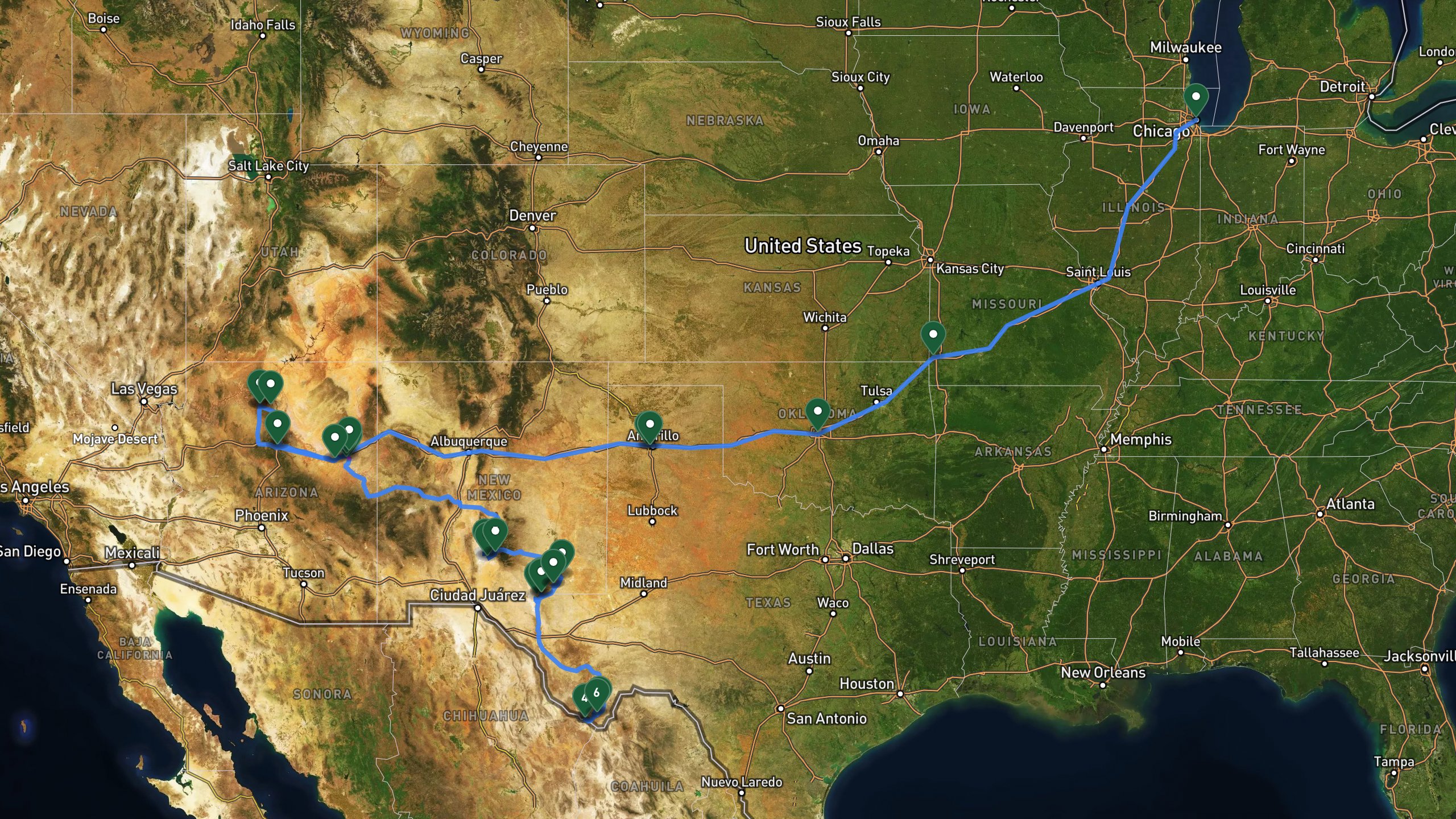
Route overview, not navigation
Stops are shown at place level. Each leg is coloured by the travel mode we infer from the stops at either end, then drawn along that network: blue for driving and magenta for walking. The mode is our inference, not a confirmed record of how the route was travelled. A grey dashed leg is one we could not route, shown as a straight overview instead. This is an overview of the route, not a turn-by-turn track, and it is not suitable for navigation.
The itinerary
Day by day
All 38 stops, free to read. Every day is editable once the route is yours.

Photo by Alex Moliski on Unsplash
Big Bend Arrival and Santa Elena Canyon
- 70.2 mi drive
- 2.1 mi on foot
- Night: Chisos Mountains Lodge in Big Bend National Park area, Texas altitude 5,400 feet area option two alternative option.
Start at the Big Bend National Park Visitor Center to pay the entrance fee, pick up maps, fill water bottles, and check road conditions. From there, drive to the Santa Elena Canyon Trailhead, a paved road accessible by any car. The trail itself is an easy 1.7 mile round trip that leads into a canyon with walls towering 1,500 feet overhead, with a creek crossing at the start and welcome shade from the cliffs. After returning to the trailhead, drive to the Chisos Basin for the night, where a mountain lodge sits at 5,400 feet elevation with mountain views and on site dining.
Big Bend National Park Visitor CenterDrive
Park entrance and visitor center. Pay entry fee, grab maps, fill water, check road conditions.
+34.2 mi along the route
Santa Elena Canyon TrailheadDrive
Trailhead parking for Santa Elena Canyon trail. Paved road accessible by car.
+1.1 mi along the route
Santa Elena CanyonHike
1.7 mile round trip into towering 1,500-foot canyon walls. Creek crossing at start, shaded by cliffs.
+1.1 mi along the route
Santa Elena Canyon TrailheadDrive
Return to trailhead and drive back east.
+36 mi along the route
Mountain Lodge in Chisos Basinlodge
Lodge in the Chisos Basin mountain area at 5,400 feet elevation with mountain views and on-site dining.

Photo by Hoyt Roberson on Unsplash
Guadalupe Mountains to Carlsbad
- 324 mi drive
- 3 mi on foot
- Night: Hotel in Carlsbad, New Mexico area
Leave the Chisos Basin lodge early to beat the heat, grabbing breakfast to go if it is available. The drive to the Guadalupe Mountains National Park Visitor Center covers about 255 miles, where you can pay the entrance fee, refill water, and check trail conditions for McKittrick Canyon. A short paved drive brings you to the McKittrick Canyon Trailhead for an easy 2.4 mile round trip to Pratt Cabin, a desert canyon with riparian forest often called the most beautiful spot in Texas. From the trailhead, continue on to Carlsbad for the night at a modern hotel with a pool, hot breakfast, and air conditioning, a good base for the caverns the next day.
Mountain Lodge in Chisos Basinlodge
Depart lodge early to beat heat. Grab breakfast to go if available.
+255 mi along the route
Guadalupe Mountains National Park Visitor CenterDrive
Park headquarters. Pay entrance fee, grab water, check trail conditions for McKittrick Canyon.
+8.7 mi along the route
McKittrick Canyon TrailheadDrive
Trailhead parking for McKittrick Canyon. Paved access road from visitor center.
+1.5 mi along the route
McKittrick CanyonHike
Easy 2.4-mile round trip to Pratt Cabin through stunning desert canyon with riparian forest. Called the most beautiful spot in Texas.
+1.5 mi along the route
McKittrick Canyon TrailheadDrive
Return to trailhead and drive to Carlsbad for the night.
+60.9 mi along the route
Hotel in Carlsbad Arealodge
Modern hotel with pool, hot breakfast, and AC. Perfect base for Carlsbad Caverns tomorrow.

Photo by Cate Bligh on Unsplash
Carlsbad Caverns and White Sands
- 168 mi drive
- 2 mi on foot
- Night: Hotel in Alamogordo, New Mexico area
After an early checkout and hotel breakfast, drive about 24 miles to the Carlsbad Caverns Visitor Center to purchase entry tickets, rent an audio guide, and use the restrooms before heading underground. The hike covers roughly 1 mile descending via the Natural Entrance, dropping about 750 feet, followed by a 1.25 mile loop through the Big Room among massive underground chambers and spectacular formations. Ride the elevator back up to the visitor center for a lunch break before the roughly 112 mile drive west to the White Sands Visitor Center, where you can pay the entry fee, rent a sled, and check Dunes Drive conditions. At the end of Dunes Drive, park at the Alkali Flat Trail area to explore the pure white gypsum dunes on foot and by sled. Return sleds, exit the park, and drive on to Alamogordo for the night at a hotel with an outdoor pool, hot breakfast, and air conditioning, close to area restaurants.
Hotel in Carlsbad Arealodge
Early checkout. Grab breakfast at hotel before departing for the caverns.
+23.6 mi along the route
Carlsbad Caverns Visitor CenterDrive
National park visitor center. Purchase entry tickets, rent audio guide, use restrooms before descent.
+1 mi along the route
Carlsbad Caverns Big RoomHike
1 mile descent via Natural Entrance (750 feet down), then 1.25-mile loop through the Big Room. Massive underground chambers with spectacular formations.
+1 mi along the route
Carlsbad Caverns Visitor CenterDrive
Return to visitor center via elevator. Lunch break before driving west to White Sands.
+112 mi along the route
White Sands Visitor CenterDrive
White Sands National Park entrance. Pay entry fee, rent sled, grab water, check Dunes Drive conditions.
+7.5 mi along the route
Alkali Flat Trail ParkingDrive
End of Dunes Drive. Park and explore the pure white gypsum dunes on foot and sled.
+7.5 mi along the route
White Sands Visitor CenterDrive
Return sleds and exit park.
+17.4 mi along the route
Hotel in Alamogordo Arealodge
Comfortable hotel with outdoor pool, hot breakfast, and AC. Close to restaurants in the area.

Photo by Joseph Corl on Unsplash
Petrified Forest and Painted Desert
- 317 mi drive
- 27.3 mi on foot
- Night: Hotel in Holbrook, Arizona area
It is a long drive day, about 295 miles, from Alamogordo to the Petrified Forest National Park South Entrance, so an early checkout with hotel breakfast helps get things moving. At the visitor center, pay the entrance fee, grab a park map, and check conditions for the scenic drive. Stop at the Crystal Forest Trail for an easy 0.75 mile loop through a dense concentration of colorful petrified logs, fully exposed with no shade, then continue to Blue Mesa for a 1 mile loop through striking blue and purple badlands scattered with petrified wood. Before exiting the park at the north entrance, stop at the Painted Desert Inn, a historic building with a viewpoint overlooking the Painted Desert. Finish the day with a short drive to Holbrook, staying at a family friendly hotel with an outdoor pool, free breakfast, and air conditioning, close to Route 66 area diners.
Hotel in Alamogordo Arealodge
Early checkout with hot breakfast. Long drive day ahead to Arizona.
+295 mi along the route
Petrified Forest National Park South EntranceDrive
Park entrance and visitor center. Pay entry fee, grab park map, check road conditions for scenic drive.
+7.5 mi along the route
Crystal Forest TrailHike
Easy 0.75-mile loop through dense concentration of colorful petrified logs. Fully exposed, no shade.
+7.5 mi along the route
Blue MesaHike
1-mile loop through stunning blue and purple badlands with petrified wood scattered throughout.
+12.4 mi along the route
Painted Desert InnDrive
Historic inn and viewpoint overlooking the Painted Desert. Final stop before exiting north entrance.
+21.7 mi along the route
Hotel in Holbrook Arealodge
Family-friendly hotel with outdoor pool, free breakfast, and AC. Close to Route 66 area diners.

Grand Canyon South Rim
- 206 mi drive
- 1.4 mi on foot
- Night: Hotel in Flagstaff, Arizona area
After an early checkout and breakfast in Holbrook, it is about 109 miles to the Grand Canyon National Park South Rim Entrance, where you pay the entry fee and pick up maps. At Mather Point, take in the iconic South Rim view from behind safe railings, then walk about 0.6 miles west along the paved Rim Trail to Yavapai Point, home to the Yavapai Geology Museum with expansive canyon views and educational displays suited to all ages. From there, drive about 26 miles to the Desert View Watchtower, a historic 70 foot stone tower at the east end of the South Rim with panoramic views of the canyon and the Colorado River. The day ends with a drive to Flagstaff, staying at a family hotel with an indoor pool, free hot breakfast, evening snacks, and easy access to the historic downtown area.
Hotel in Holbrook Arealodge
Early checkout with hot breakfast. Grand Canyon day ahead.
+109 mi along the route
Grand Canyon National Park South Rim EntranceDrive
Grand Canyon National Park South Rim entrance. Pay entry fee, grab maps, use restrooms.
+0.7 mi along the route
Mather PointHike
Iconic South Rim viewpoint with safe railings. Walk 0.6 miles west along paved Rim Trail to Yavapai Point for stunning canyon views.
+0.6 mi along the route
Yavapai PointDrive
Yavapai Geology Museum with expansive canyon views. Educational displays perfect for all ages.
+26.1 mi along the route
Desert View WatchtowerDrive
Historic 70-foot stone tower at the east end of South Rim with panoramic canyon and Colorado River views.
+71.5 mi along the route
Hotel in Flagstaff Arealodge
Family hotel with indoor pool, free hot breakfast, and evening snacks. Close to historic downtown area.

Photo by Evelyn Okay on Unsplash
The Long Drive to Texas
- 557 mi drive
- Night: Hotel in Amarillo, Texas area
This is the longest driving day of the trip, covering roughly 550 miles from Flagstaff to the Texas Panhandle. After an early checkout and hotel breakfast, the route leads to a roadside art installation, an iconic display of vintage cars buried nose down in a field, free to visit and interact with. From there it is a short 7 mile hop into Amarillo for the night, staying at a comfortable hotel with an indoor pool, hot breakfast, and air conditioning, close to area restaurants.
Hotel in Flagstaff Arealodge
Early checkout with hot breakfast. Long drive day ahead to Texas Panhandle.
+550 mi along the route
Roadside Art Installationactivity
Iconic roadside art installation of vintage cars buried nose-down in a field. Free to visit and interact with.
+6.8 mi along the route
Hotel in Amarillo Arealodge
Comfortable hotel with indoor pool, hot breakfast, and AC. Close to area restaurants.

The Long Road Home
- 1,004 mi drive
- Night: Home in Chicago, Illinois
The final day is a long haul of about 415 miles back to Chicago. After an early checkout and hotel breakfast in Amarillo, the first break comes at an Oklahoma City rest stop for fuel, a meal, and a chance to stretch your legs, roughly 267 miles in. A second stop in the Joplin, Missouri area, about 224 miles later, offers a quick snack or coffee break. From there, it is a final push of about 513 miles into Chicago, Illinois, marking the end of an epic roughly 3,400 mile Southwest road trip through six national parks.
Hotel in Amarillo Arealodge
Early checkout with hot breakfast. Final long drive home to Chicago.
+267 mi along the route
Oklahoma City Rest StopDrive
Fuel and meal break in Oklahoma City area. Stretch legs and use restrooms.
+224 mi along the route
Joplin Missouri Rest StopDrive
Fuel and stretch break in Joplin area. Quick snack or coffee stop.
+513 mi along the route
Chicago, IllinoisDrive
Home! End of an epic 3,400-mile Southwest road trip through 6 national parks.
7 days does not quite fit?
Take this route as your starting point and reshape it around your dates, your pace, and the stops you care about most.
WHAT XPLORERS ARE SAYING
I discovered Xploreum yesterday while searching for an app to plan a road trip to Newfoundland and Labrador. The conversational approach allows us to pinpoint exactly our needs and expectations and build an ideal itinerary. Highly recommended!
I took a look at the program and found it quite cool to use. I did not give it a lot of prompts and it gave me a really neat place to hike in my home state. I think it works really well.
I’m sitting and planning summer vacation trips. This year, Christian and I are going on a road trip, most likely to Eastern Europe. That also gives me a reason to tell you about this insanely cool AI model. Xploreum.io has developed a model that can help you find the coolest places that aren’t touristy, and it can actually put together an entire trip for you. It’s insanely smart. Not an ad. Just a genuine recommendation.
Before you go
What this route assumes
Only the fields this route actually holds data for.
Where you sleep
Overnight areas in route order: Chisos Mountains Lodge in Big Bend National Park area, Texas altitude 5,400 feet area option two alternative option., Hotel in Carlsbad, New Mexico area, Hotel in Alamogordo, New Mexico area, Hotel in Holbrook, Arizona area, Hotel in Flagstaff, Arizona area, Hotel in Amarillo, Texas area, Home in Chicago, Illinois. Xavier pairs each with live lodging options once the route is yours.
Vehicle
Built as a regular car route, overlanding and easy hiking. Xavier adapts it to what you actually drive.
Level
Paced for easy travelers. Days can be split or merged to change the load.
How this Xpedition was built
Assembled from structured route and waypoint records, not written as an article, and reviewed before publication. Confirm conditions, closures, and permits before you travel.
- Route structured
- Distances calculated
- Reviewed before publication
- Published August 2026
More Xpeditions
See all
5-Day Itinerary: NYC to Niagara Falls, Ontario
This 5-day trip flies from the southern USA into New York City for a night of sightseeing and Broadway, takes the train to Buffalo, then drives into Niagara Falls, Ontario for two full days of gorge hikes, waterfall tours, wine country, and maple syrup tasting before returning home.
Major Airport - Southern USANiagara Falls Canada AccommodationHome
5 days3,751 km driving47 stopsmoderate

3-Day Road Trip Itinerary: Merrimack, NH to Cody, WY
This 3-day drive covers roughly 1,975 miles from Merrimack, New Hampshire to Cody, Wyoming, with overnight stops in South Bend, Indiana and Custer, South Dakota, taking in the Badlands, Custer State Park, and the Bighorn Mountains along the way.
Departure location, Merrimack NH areaFairfield Inn & Suites South Bend, IN area overnight stay (South Bend)The Cody Hotel, Cody WY overnight stay (Cody area)Hotel, Cody area
3 days2,244 mi driving15 stopseasy

Anniversary Drive to Coastal Maine: 5-Day Camden Road Trip Itinerary
A 5-day scenic road trip from Daytona Beach to Camden, Maine, featuring fall foliage hikes in Connecticut, coastal harbor towns, Acadia National Park, and boutique lodging for a romantic anniversary getaway.
Daytona Beach DepartureFamily Home, New Jersey area.Home, Daytona Beach, Florida area.Daytona Beach
5 days3,080 mi driving28 stopsmoderate
Make this Xpedition yours.
Dates, pace, lodging, vehicle, and who is coming can all be rebuilt around you, starting from this exact route: 7 Days Big Bend to Chicago via Southwest Parks: A Road Trip Itinerary.
You keep
- The full 7 day route, editable day by day
- Distances and pacing recalculated around you
- One conversation to change anything