


3 Days Hiking in Sedona: Cathedral Rock, West Fork, Boynton Canyon & Devils Bridge Itinerary
This 3 day itinerary explores Sedona, Arizona on foot, using a West Sedona base for two nights before returning to the Phoenix area. Each day pairs a scenic drive with one or two moderate hikes, taking in famous red rock landmarks such as Cathedral Rock, Bell Rock, West Fork Oak Creek, Boynton Canyon, Doe Mountain, and Devils Bridge. The pace is relaxed enough to include local meals in Central Sedona and Oak Creek Canyon, and a 4x4 SUV is recommended for trailhead access. Total hiking distance across the trip is about 10.2 miles with roughly 730 feet of cumulative elevation gain, making it approachable for hikers with a moderate fitness level.
Built stop by stop, not written as an article.
Xavier starts with this location and helps you build your own version of the trip.
- Days
- 3
- Stops
- 27
- Driving
- 288 mi
- On foot
- 32.3 mi
- Overnights
- 3
- Level
- moderate
Published by Xploreum · August 2026
ARE YOU XPLORER MATERIAL?
The average Xplorer every year...
Sleeps outside 24 nights
Explores 1,800 miles
Covers 500 miles on foot, skis, bikes, boats and trails
Experiences a 120°F temperature difference
Discovers 18 new places
Does something for the first time 18 times
Sees the Milky Way 11 nights
Takes 6 people on their first adventure
Spends 240 hours away from notifications
Creates stories remembered for decades
The shape of it
How the route moves
3 days and 27 stops, covering 288 mi of driving, 32.3 mi on foot. Every distance comes from the route records behind this Xpedition.
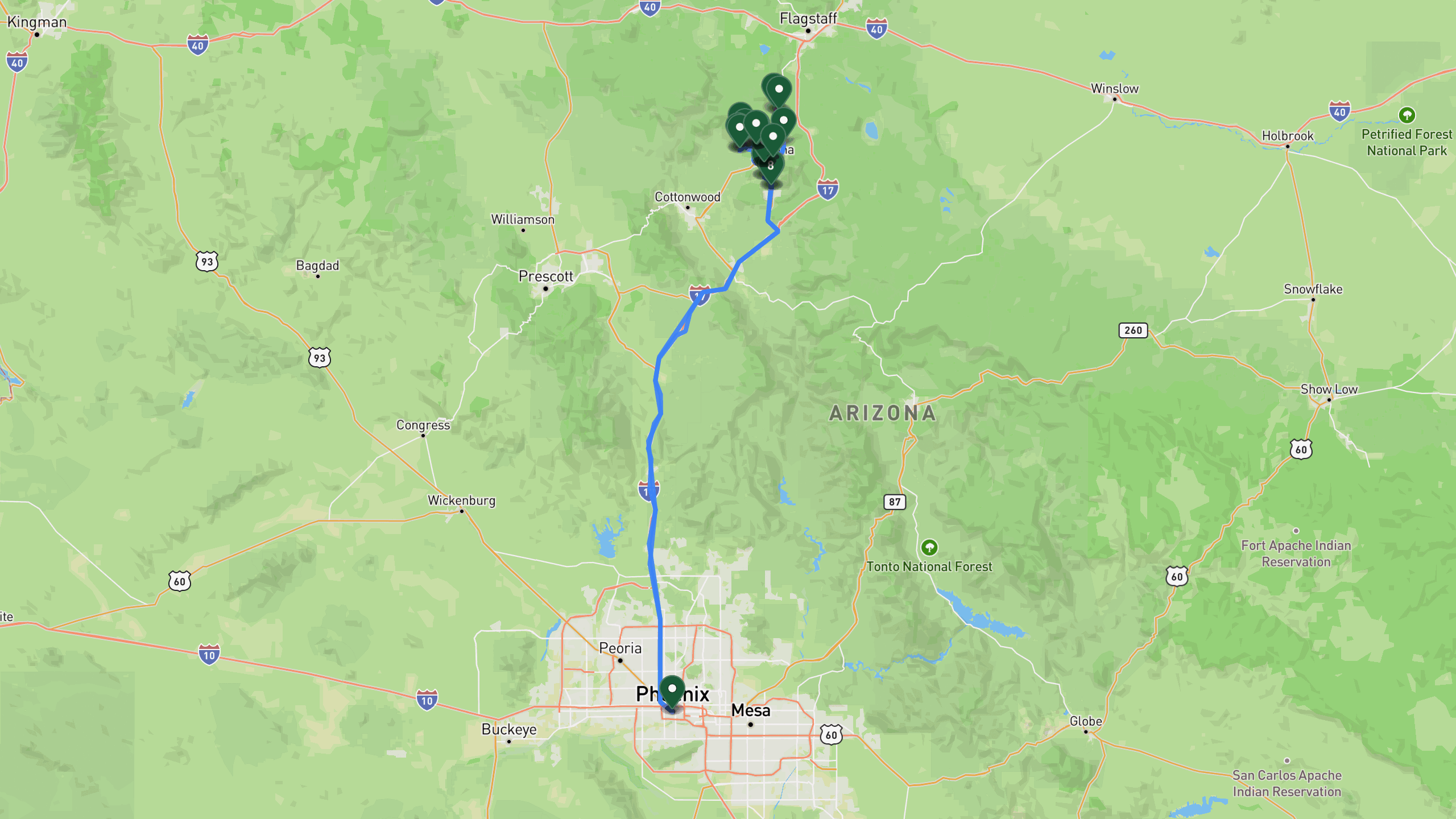
Route overview, not navigation
Stops are shown at place level. Each leg is coloured by the travel mode we infer from the stops at either end, then drawn along that network: blue for driving and magenta for walking. The mode is our inference, not a confirmed record of how the route was travelled. A grey dashed leg is one we could not route, shown as a straight overview instead. This is an overview of the route, not a turn-by-turn track, and it is not suitable for navigation.
The itinerary
Day by day
All 27 stops, free to read. Every day is editable once the route is yours.

Photo by Sébastien Noël on Unsplash
Cathedral Rock and Bell Rock
- 127 mi drive
- 7.7 mi on foot
- Night: Sedona lodging area, West side area.Total distance driven: 212.5 km. Hiked: 2.6 km. Elevation gain: 120 m.
The trip begins with a drive from the Phoenix area to Sedona, arriving at the Cathedral Rock trailhead, where a day use pass is required. The Cathedral Rock hike is a popular Sedona scramble climbing to a saddle viewpoint, covering about 1.5 miles round trip with roughly 740 feet of elevation gain. Expect a steep slickrock section with handholds near the top. After the hike, head into Central Sedona for lunch at an upscale Mexican restaurant known for local cuisine and grilled specialties. In the afternoon, drive to the Bell Rock trailhead, where the same day use pass applies. The Bell Rock loop circles this iconic formation over about 3.8 miles round trip with around 400 feet of elevation gain, following a wide trail with optional scramble sections for those who want a closer look at the rock. The day wraps up at boutique lodging in West Sedona, offering red rock views and breakfast included, where you will also stay the second night.
Phoenix area departureDrive
Starting point from Phoenix area.
+109 mi along the route
Cathedral Rock trailhead areaDrive
Trailhead parking for Cathedral Rock hike. Day use pass required.
+1.5 mi along the route
Cathedral Rock summitHike
Popular Sedona scramble to saddle viewpoint. 1.5 miles round trip, 740 ft elevation gain. Steep slickrock section with handholds.
+1.5 mi along the route
Cathedral Rock trailhead areaDrive
Return to trailhead area.
+5 mi along the route
Local Mexican restaurant, Central Sedonameal
Upscale Mexican dining in Central Sedona area. Features local cuisine and grilled specialties.
+6.8 mi along the route
Bell Rock trailhead areaDrive
Trailhead parking for Bell Rock loop. Day use pass valid.
+2.4 mi along the route
Bell Rock loopHike
Loop around iconic Bell Rock formation. 3.8 miles round trip, 400 ft elevation gain. Wide trail with optional scramble sections.
+2.4 mi along the route
Bell Rock trailhead areaDrive
Return to trailhead area.
+6.2 mi along the route
Boutique lodging, West Sedonalodge
Boutique accommodations with red rock views in West Sedona area. Includes breakfast.

Photo by Frank Thiemonge on Unsplash
West Fork Oak Creek and Boynton Canyon
- 36 mi drive
- 15.4 mi on foot
- Night: Sedona lodging area, West side area. Total distance driven: 60.9 km. Hiked: 11.9 km. Elevation gain: 213 m.
After breakfast at the lodge, drive to the West Fork Oak Creek trailhead, where a day use pass is required. This canyon slot hike winds through cottonwood groves with multiple creek crossings, covering about 6.8 miles round trip with roughly 200 feet of elevation gain. Be prepared for stream crossings along the way. From there, head to a local cafe in the Oak Creek Canyon area for burgers, sandwiches, or baked goods, with creekside patio seating for a relaxed break. In the afternoon, drive to the Boynton Canyon trailhead, where the day use pass remains valid. The hike follows a wide trail into a box canyon framed by towering red rock walls, covering about 5.6 miles round trip with around 450 feet of elevation gain. Return to the boutique lodging in West Sedona for a second night.
Boutique lodging, West Sedonalodge
Depart after breakfast.
+14.3 mi along the route
West Fork Oak Creek trailhead areaDrive
Trailhead parking for West Fork hike. Day use pass required.
+4.2 mi along the route
West Fork Oak CreekHike
Canyon slot hike through cottonwood groves with creek crossings. 6.8 miles round trip, 200 ft elevation gain. Multiple stream crossings required.
+4.2 mi along the route
West Fork Oak Creek trailhead areaDrive
Return to trailhead area.
+6.2 mi along the route
Cafe in Oak Creek Canyon areameal
Local cafe in Oak Creek Canyon area. Burgers, sandwiches, baked goods. Creekside patio seating.
+9.9 mi along the route
Boynton Canyon trailhead areaDrive
Trailhead parking for Boynton Canyon hike. Day use pass valid.
+3.5 mi along the route
Boynton Canyon vistaHike
Canyon framed by towering red rock walls. 5.6 miles round trip, 450 ft elevation gain. Wide trail to box canyon.
+3.5 mi along the route
Boynton Canyon trailhead areaDrive
Return to trailhead area.
+5.6 mi along the route
Boutique lodging, West Sedonalodge
Return to lodging for second night.

Photo by Frank Thiemonge on Unsplash
Doe Mountain and Devils Bridge
- 126 mi drive
- 9.2 mi on foot
- Night: Phoenix area. Total distance driven: 215.2 km. Hiked: 2.1 km. Elevation gain: 70 m.
An early departure sets up a sunrise hike at Doe Mountain, where a day use pass is required at the trailhead. The trail climbs to a flat-topped mesa offering 360-degree red rock views, covering about 3.2 miles round trip with roughly 400 feet of elevation gain, with especially good light in the early morning. Next, drive to the Devils Bridge trailhead, where the day use pass still applies. This hike leads to the largest natural sandstone arch in Sedona, a well-known scenic photo spot, covering about 4.2 miles round trip with around 400 feet of elevation gain. Before heading back, stop at a bakery cafe in Central Sedona for sandwiches, salads, or pastries, a quick lunch to fuel the drive back to the Phoenix area, which completes the itinerary.
Boutique lodging, West Sedonalodge
Early departure for sunrise hike.
+5.6 mi along the route
Doe Mountain trailhead areaDrive
Trailhead parking for Doe Mountain hike. Day use pass required.
+2 mi along the route
Doe Mountain summitHike
Flat-topped mesa with 360-degree red rock views. 3.2 miles round trip, 400 ft elevation gain. Sunrise light on rock formations.
+2 mi along the route
Doe Mountain trailhead areaDrive
Return to trailhead area.
+5 mi along the route
Devils Bridge trailhead areaDrive
Trailhead parking for Devils Bridge hike. Day use pass valid.
+2.6 mi along the route
Devils BridgeHike
Largest natural sandstone arch in Sedona. 4.2 miles round trip, 400 ft elevation gain. Scenic photo location.
+2.6 mi along the route
Devils Bridge trailhead areaDrive
Return to trailhead area.
+6.2 mi along the route
Bakery cafe, Central Sedonameal
Bakery cafe in Central Sedona. Sandwiches, salads, pastries. Quick lunch before return trip.
+109 mi along the route
Phoenix area arrivalDrive
Return to Phoenix area.
3 days does not quite fit?
Take this route as your starting point and reshape it around your dates, your pace, and the stops you care about most.
WHAT XPLORERS ARE SAYING
I discovered Xploreum yesterday while searching for an app to plan a road trip to Newfoundland and Labrador. The conversational approach allows us to pinpoint exactly our needs and expectations and build an ideal itinerary. Highly recommended!
I took a look at the program and found it quite cool to use. I did not give it a lot of prompts and it gave me a really neat place to hike in my home state. I think it works really well.
I’m sitting and planning summer vacation trips. This year, Christian and I are going on a road trip, most likely to Eastern Europe. That also gives me a reason to tell you about this insanely cool AI model. Xploreum.io has developed a model that can help you find the coolest places that aren’t touristy, and it can actually put together an entire trip for you. It’s insanely smart. Not an ad. Just a genuine recommendation.
Before you go
What this route assumes
Only the fields this route actually holds data for.
Where you sleep
Overnight areas in route order: Sedona lodging area, West side area.Total distance driven: 212.5 km. Hiked: 2.6 km. Elevation gain: 120 m., Sedona lodging area, West side area. Total distance driven: 60.9 km. Hiked: 11.9 km. Elevation gain: 213 m., Phoenix area. Total distance driven: 215.2 km. Hiked: 2.1 km. Elevation gain: 70 m.. Xavier pairs each with live lodging options once the route is yours.
Vehicle
Built as a 4x4 suv route, hiking, hub-and-spoke. Xavier adapts it to what you actually drive.
Level
Paced for moderate travelers. Days can be split or merged to change the load.
How this Xpedition was built
Assembled from structured route and waypoint records, not written as an article, and reviewed before publication. Confirm conditions, closures, and permits before you travel.
- Route structured
- Distances calculated
- Reviewed before publication
- Published August 2026
More Xpeditions
See all
5-Day Itinerary: NYC to Niagara Falls, Ontario
This 5-day trip flies from the southern USA into New York City for a night of sightseeing and Broadway, takes the train to Buffalo, then drives into Niagara Falls, Ontario for two full days of gorge hikes, waterfall tours, wine country, and maple syrup tasting before returning home.
Major Airport - Southern USANiagara Falls Canada AccommodationHome
5 days3,751 km driving47 stopsmoderate

3-Day Road Trip Itinerary: Merrimack, NH to Cody, WY
This 3-day drive covers roughly 1,975 miles from Merrimack, New Hampshire to Cody, Wyoming, with overnight stops in South Bend, Indiana and Custer, South Dakota, taking in the Badlands, Custer State Park, and the Bighorn Mountains along the way.
Departure location, Merrimack NH areaFairfield Inn & Suites South Bend, IN area overnight stay (South Bend)The Cody Hotel, Cody WY overnight stay (Cody area)Hotel, Cody area
3 days2,244 mi driving15 stopseasy

Anniversary Drive to Coastal Maine: 5-Day Camden Road Trip Itinerary
A 5-day scenic road trip from Daytona Beach to Camden, Maine, featuring fall foliage hikes in Connecticut, coastal harbor towns, Acadia National Park, and boutique lodging for a romantic anniversary getaway.
Daytona Beach DepartureFamily Home, New Jersey area.Home, Daytona Beach, Florida area.Daytona Beach
5 days3,080 mi driving28 stopsmoderate
Make this Xpedition yours.
Dates, pace, lodging, vehicle, and who is coming can all be rebuilt around you, starting from this exact route: 3 Days Hiking in Sedona: Cathedral Rock, West Fork, Boynton Canyon & Devils Bridge Itinerary.
You keep
- The full 3 day route, editable day by day
- Distances and pacing recalculated around you
- One conversation to change anything