
Photo by Michael Denning on Unsplash

Photo by Hasnain Sikora on Unsplash

Photo by Raphael Assouline on Unsplash

Photo by Leslie Cross on Unsplash
3 Days Backpacking Acadia National Park, Maine
This 3 day itinerary explores Acadia National Park, Maine, through a mix of backpacking and day hiking. It begins with a drive from Portland to the park's Hulls Cove Visitor Center, followed by the iconic Beehive Trail and lunch at Jordan Pond House. After picking up backcountry permits, a ferry carries travelers to remote Isle au Haut for two nights at the Duck Harbor lean-to. The middle day is spent exploring rugged coastal trails along Western Head and Cliff Trail, with sweeping Atlantic views. The final day includes the hike out and ferry back to Stonington, a visit to the dramatic granite shoreline of Schoodic Point, and a picnic lunch before returning to Portland. The trip suits a moderate skill level and is designed for travel by 4x4 SUV.
Built stop by stop, not written as an article.
Xavier starts with this location and helps you build your own version of the trip.
- Days
- 3
- Stops
- 21
- Driving
- 281 mi
- On foot
- 15.7 mi
- Level
- moderate
Published by Xploreum · August 2026
ARE YOU XPLORER MATERIAL?
The average Xplorer every year...
Sleeps outside 24 nights
Explores 1,800 miles
Covers 500 miles on foot, skis, bikes, boats and trails
Experiences a 120°F temperature difference
Discovers 18 new places
Does something for the first time 18 times
Sees the Milky Way 11 nights
Takes 6 people on their first adventure
Spends 240 hours away from notifications
Creates stories remembered for decades
The shape of it
How the route moves
3 days and 21 stops, covering 281 mi of driving, 15.7 mi on foot. Every distance comes from the route records behind this Xpedition.
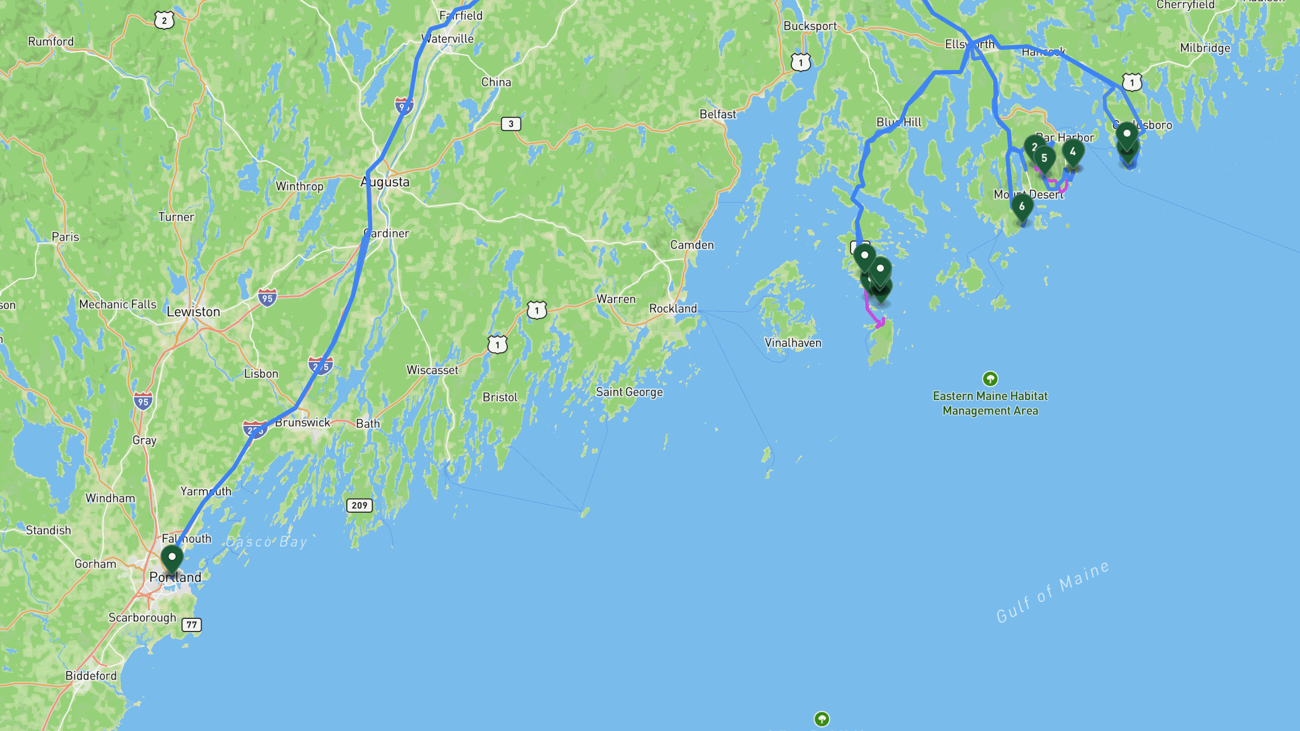
Route overview, not navigation
Stops are shown at place level. Each leg is coloured by the travel mode we infer from the stops at either end, then drawn along that network: blue for driving and magenta for walking. The mode is our inference, not a confirmed record of how the route was travelled. A grey dashed leg is one we could not route, shown as a straight overview instead. This is an overview of the route, not a turn-by-turn track, and it is not suitable for navigation.
The itinerary
Day by day
All 21 stops, free to read. Every day is editable once the route is yours.

Portland to Duck Harbor via the Beehive Trail
- 153 mi drive
- 1.5 mi on foot
The trip begins with a drive of about 109 miles from the Portland area to Acadia National Park's Hulls Cove Visitor Center, where you can pick up permits and backcountry information. From there, head to the Beehive Trail for an exposed, iron-rung ladder climb to panoramic views over Sand Beach and the Atlantic. The hike is about 1.2 miles round-trip with roughly 450 feet of elevation gain. After returning to the trailhead, drive about 5 miles to Jordan Pond House for lunch overlooking Jordan Pond, where the local tradition of popovers and tea awaits. Next, drive roughly 10 miles to the Seawall Campground Backcountry Permit Office to finalize backcountry permits and confirm your site assignment. From there, it is about 28 miles, including a ferry crossing from Stonington, to reach the Duck Harbor Trailhead on remote Isle au Haut. A final 0.7 mile hike brings you to Duck Harbor Lean-to #2, a backcountry shelter overlooking Duck Harbor, where you will spend the first night.
Portland, ME DepartureDrive
Departure from Portland area
+109 mi along the route
Acadia National Park Hulls Cove Visitor CenterDrive
Park entrance and visitor center. Pick up permits and backcountry information.
+0.7 mi along the route
Beehive Trail SummitHike
Exposed iron-rung ladder climb to panoramic views over Sand Beach and the Atlantic. 1.2 miles round-trip, 450 ft gain.
+0.7 mi along the route
Beehive Trailhead ParkingDrive
Return to trailhead
+5 mi along the route
Jordan Pond Housemeal
Lunch stop with views overlooking Jordan Pond. Local tradition includes popovers and tea.
+9.9 mi along the route
Seawall Campground Backcountry Permit OfficeDrive
Pick up final backcountry permits and confirm site assignments.
+28 mi along the route
Duck Harbor Trailhead, Isle au HautDrive
Ferry from Stonington to Isle au Haut. Remote island backcountry access.
+0.7 mi along the route
Duck Harbor Lean-to #2lodge
Backcountry lean-to shelter overlooking Duck Harbor. 1.1 mile hike from ferry landing.

Photo by Leslie Cross on Unsplash
Coastal Loop on Isle au Haut
- 8.5 mi on foot
Wake at the Duck Harbor lean-to and pack day gear for a full day exploring the island's rugged coastline. Set out on the Western Head Trail, a rugged coastal path along granite cliffs that runs about 2 miles one-way with around 350 feet of elevation gain, offering stunning Atlantic views throughout. Return inland to the Duck Harbor Trail Junction, then head back to the lean-to for lunch and a rest. In the afternoon, hike the Cliff Trail Overlook, a southern cliffside route with sheer drops to the ocean, covering about 2.2 miles round-trip with roughly 450 feet of elevation gain. Afterward, return to Duck Harbor Lean-to #2 for a second night, with sunset settling over the harbor.
Duck Harbor Lean-to #2lodge
Wake at Duck Harbor. Pack day gear and prepare for coastal loop.
+2 mi along the route
Western Head TrailHike
Rugged coastal trail along granite cliffs. 3.2 miles one-way, 350 ft gain. Stunning Atlantic views.
+2 mi along the route
Duck Harbor Trail JunctionHike
Return to Duck Harbor junction via inland trail.
+0.2 mi along the route
Duck Harbor Lean-to #2Drive
Return to shelter for lunch and rest.
+2.2 mi along the route
Cliff Trail OverlookHike
Southern cliffside trail with sheer drops to the ocean. 3.5 miles round-trip, 450 ft gain.
+2.2 mi along the route
Duck Harbor Lean-to #2Drive
Return to shelter for the evening.
Duck Harbor Lean-to #2lodge
Second night at Duck Harbor lean-to. Sunset over the harbor.

Photo by Leslie Cross on Unsplash
Ferry Out, Schoodic Point, and Return to Portland
- 128 mi drive
- 5.7 mi on foot
Wake and pack out from Duck Harbor, following leave no trace principles as you break camp. Hike about 0.7 miles to the Duck Harbor Ferry Landing, then take the ferry roughly 5 miles back to Stonington Harbor. From Stonington, drive about 36 miles to Schoodic Point on Acadia's quieter Schoodic Peninsula, where waves crash directly onto exposed granite bedrock. Continue about 2 miles to the Schoodic Woods Campground Picnic Area for a picnic lunch, before the final drive of roughly 90 miles back to Portland, marking the end of the trip.
Duck Harbor Lean-to #2lodge
Wake and pack out from Duck Harbor. Leave no trace.
+0.7 mi along the route
Duck Harbor Ferry LandingHike
Hike out to ferry landing with full packs. 1.1 miles.
+5 mi along the route
Stonington HarborDrive
Ferry back to Stonington from Isle au Haut.
+36 mi along the route
Schoodic PointDrive
Dramatic granite point on Acadia's quieter Schoodic Peninsula. Waves crash directly onto exposed bedrock.
+1.9 mi along the route
Schoodic Woods Campground Picnic Areameal
Picnic lunch near Schoodic Woods.
+90.1 mi along the route
Portland, MEDrive
Arrive back in Portland area. End of trip.
3 days does not quite fit?
Take this route as your starting point and reshape it around your dates, your pace, and the stops you care about most.
WHAT XPLORERS ARE SAYING
I discovered Xploreum yesterday while searching for an app to plan a road trip to Newfoundland and Labrador. The conversational approach allows us to pinpoint exactly our needs and expectations and build an ideal itinerary. Highly recommended!
I took a look at the program and found it quite cool to use. I did not give it a lot of prompts and it gave me a really neat place to hike in my home state. I think it works really well.
I’m sitting and planning summer vacation trips. This year, Christian and I are going on a road trip, most likely to Eastern Europe. That also gives me a reason to tell you about this insanely cool AI model. Xploreum.io has developed a model that can help you find the coolest places that aren’t touristy, and it can actually put together an entire trip for you. It’s insanely smart. Not an ad. Just a genuine recommendation.
Before you go
What this route assumes
Only the fields this route actually holds data for.
Vehicle
Built as a 4x4 suv route, backpacking and hiking. Xavier adapts it to what you actually drive.
Level
Paced for moderate travelers. Days can be split or merged to change the load.
How this Xpedition was built
Assembled from structured route and waypoint records, not written as an article, and reviewed before publication. Confirm conditions, closures, and permits before you travel.
- Route structured
- Distances calculated
- Reviewed before publication
- Published August 2026
More Xpeditions
See all
5-Day Itinerary: NYC to Niagara Falls, Ontario
This 5-day trip flies from the southern USA into New York City for a night of sightseeing and Broadway, takes the train to Buffalo, then drives into Niagara Falls, Ontario for two full days of gorge hikes, waterfall tours, wine country, and maple syrup tasting before returning home.
Major Airport - Southern USANiagara Falls Canada AccommodationHome
5 days3,751 km driving47 stopsmoderate

3-Day Road Trip Itinerary: Merrimack, NH to Cody, WY
This 3-day drive covers roughly 1,975 miles from Merrimack, New Hampshire to Cody, Wyoming, with overnight stops in South Bend, Indiana and Custer, South Dakota, taking in the Badlands, Custer State Park, and the Bighorn Mountains along the way.
Departure location, Merrimack NH areaFairfield Inn & Suites South Bend, IN area overnight stay (South Bend)The Cody Hotel, Cody WY overnight stay (Cody area)Hotel, Cody area
3 days2,244 mi driving15 stopseasy

Anniversary Drive to Coastal Maine: 5-Day Camden Road Trip Itinerary
A 5-day scenic road trip from Daytona Beach to Camden, Maine, featuring fall foliage hikes in Connecticut, coastal harbor towns, Acadia National Park, and boutique lodging for a romantic anniversary getaway.
Daytona Beach DepartureFamily Home, New Jersey area.Home, Daytona Beach, Florida area.Daytona Beach
5 days3,080 mi driving28 stopsmoderate
Make this Xpedition yours.
Dates, pace, lodging, vehicle, and who is coming can all be rebuilt around you, starting from this exact route: 3 Days Backpacking Acadia National Park, Maine.
You keep
- The full 3 day route, editable day by day
- Distances and pacing recalculated around you
- One conversation to change anything