
Photo by Meressa Chartrand on Unsplash

Photo by Chris Czermak on Unsplash

Photo by Dimitar Donovski on Unsplash

Photo by Andrew Svk on Unsplash
10 Days Cross-Canada: Sault Ste Marie to Osoyoos Road Trip Itinerary
This cross-Canada itinerary links Sault Ste Marie to Osoyoos, BC over 10 easy days in a regular car, tracing a scenic route through Ontario's rugged north shore, the Manitoba and Saskatchewan prairies, the Rocky and Kootenay Mountains, and finally the Okanagan wine country. Highlights include the deep gorge at Ouimet Canyon, the thundering Kakabeka Falls, the riverside gathering spot of The Forks in Winnipeg, the RCMP Heritage Centre in Regina, mineral spa waters in Moose Jaw, mountain waterfalls at Lundbreck Falls and Numa Falls, the turquoise waters of Marble Canyon, a soak at Nakusp Hot Springs, and lakefront time in Penticton before reaching the warm waters of Osoyoos Lake.
Built stop by stop, not written as an article.
Xavier starts with this location and helps you build your own version of the trip.
- Days
- 10
- Stops
- 31
- Driving
- 3,255 km
- Overnights
- 8
- Level
- easy
Published by Xploreum · August 2026
ARE YOU XPLORER MATERIAL?
The average Xplorer every year...
Sleeps outside 24 nights
Explores 1,800 miles
Covers 500 miles on foot, skis, bikes, boats and trails
Experiences a 120°F temperature difference
Discovers 18 new places
Does something for the first time 18 times
Sees the Milky Way 11 nights
Takes 6 people on their first adventure
Spends 240 hours away from notifications
Creates stories remembered for decades
The shape of it
How the route moves
10 days and 31 stops, covering 3,255 km of driving. Every distance comes from the route records behind this Xpedition.
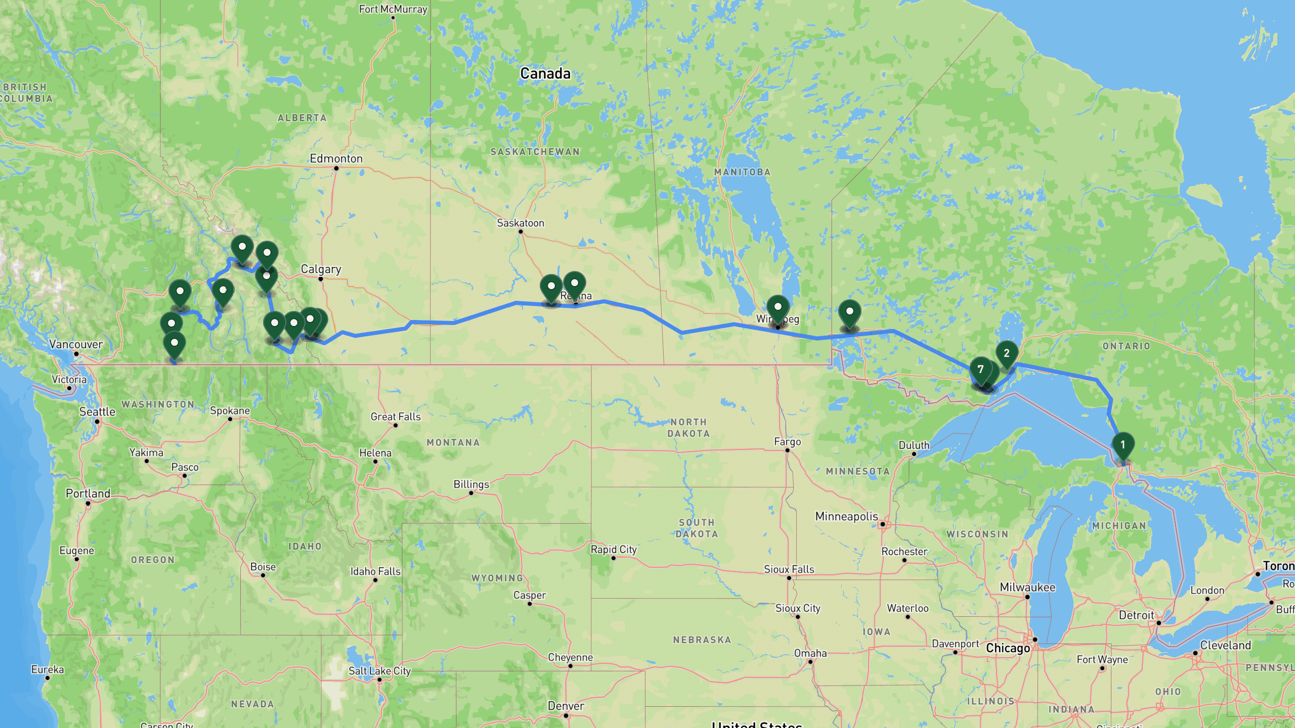
Route overview, not navigation
Stops are shown at place level. Each leg is coloured by the travel mode we infer from the stops at either end, then drawn along that network: blue for driving. The mode is our inference, not a confirmed record of how the route was travelled. A grey dashed leg is one we could not route, shown as a straight overview instead. This is an overview of the route, not a turn-by-turn track, and it is not suitable for navigation.
The itinerary
Day by day
All 31 stops, free to read. Every day is editable once the route is yours.

Photo by Calvin Lecuyer on Unsplash
The North Shore
- 405 km drive
- Night: Hotel in Thunder Bay area, Thunder Bay region. Total_km_driven: 737, total_km_hiked: 1, elevation_gain_m: 20
Begin the journey at the Sault Ste Marie Canal National Historic Site, the starting point for this cross-Canada drive. Head west along Lake Superior's rugged shoreline to Ouimet Canyon Provincial Park, where an easy 1 km boardwalk trail leads to two platforms overlooking a dramatic canyon roughly 100 metres deep. The day ends at a hotel in the Thunder Bay area, with free parking and breakfast included. In total, expect about 737 km of driving, 1 km of walking, and only 20 metres of elevation gain.
Sault Ste Marie Canal National Historic SiteDrive
Starting point at the historic canal district in Sault Ste Marie.
+315 km along the route
Ouimet Canyon Provincial Parkactivity
Dramatic 100m deep canyon with easy 1 km boardwalk trail to two viewing platforms. Stunning geological feature.
+90 km along the route
Hotel in Thunder Bay arealodge
Comfortable highway accommodation with free parking and breakfast included.

Falls and the Lake of the Woods
- 460 km drive
- Night: Hotel in Kenora area, Kenora. Total_km_driven: 495.5, total_km_hiked: 1, elevation_gain_m: 15
Leaving Thunder Bay, the first stop is Kakabeka Falls Provincial Park, home to a 40 metre waterfall on the Kaministiquia River often called the Niagara of the North. An easy 500 metre boardwalk loop takes you to upper and lower viewing platforms with excellent seasonal water flow. From there, continue west to Kenora Harbourfront Park, a scenic waterfront spot on Lake of the Woods with a boardwalk, cafes, and lake views. Overnight in the Kenora area at a clean highway hotel with free parking and breakfast. The day covers about 495.5 km of driving and 1 km on foot, with 15 metres of elevation gain.
Hotel in Thunder Bay arealodge
Departure from Thunder Bay area hotel.
+29 km along the route
Kakabeka Falls Provincial ParkDrive
Parking at the Niagara of the North. 40m waterfall on the Kaministiquia River.
+0.5 km along the route
Kakabeka Falls Viewing Platformactivity
Easy 500m boardwalk loop to upper and lower viewing platforms of the 40m waterfall. Excellent seasonal water flow.
+0.5 km along the route
Kakabeka Falls Provincial ParkDrive
Return to parking and continue west toward Kenora.
+427 km along the route
Kenora Harbourfront Parkactivity
Beautiful waterfront park on Lake of the Woods. Boardwalk, cafes, and stunning lake views.
+3 km along the route
Hotel in Kenora arealodge
Clean highway accommodation with free parking and breakfast included.

Photo by Eleanor Carter on Unsplash
Prairie Capital
- 209 km drive
- Night: Hotel in Winnipeg area, Winnipeg. Total_km_driven: 216.8, total_km_hiked: 0, elevation_gain_m: 0
From Kenora, the route heads into Manitoba toward Winnipeg. Stop at The Forks National Historic Site, the historic meeting place where the Red and Assiniboine Rivers converge, offering riverside trails, a market, shops, and cafes to explore. Settle in for the night at a modern downtown Winnipeg hotel within walking distance of the Exchange District, with free parking included. This is a shorter driving day at about 216.8 km, with no significant hiking or elevation gain.
Hotel in Kenora arealodge
Departure from Kenora area hotel.
+207 km along the route
The Forks National Historic Siteactivity
Historic meeting place at the junction of Red and Assiniboine Rivers. Riverside trails, market, shops, and cafes.
+2 km along the route
Hotel in Winnipeg arealodge
Modern downtown accommodation with free parking and walking distance to Exchange District.

Prairie Heritage
- 643 km drive
- Night: Hotel in Moose Jaw area, Moose Jaw. Total_km_driven: 651, total_km_hiked: 0, elevation_gain_m: 0
A long westward push takes you from Winnipeg to Saskatchewan. Along the way, visit the RCMP Heritage Centre, an interactive museum covering RCMP history and Canadian policing heritage, complete with modern exhibits, a memorial, and the historic depot. The night is spent in Moose Jaw at a historic downtown hotel and spa featuring natural geothermal mineral pools, a relaxing reward after roughly 651 km of driving.
Hotel in Winnipeg arealodge
Departure from Winnipeg area hotel.
+571 km along the route
RCMP Heritage Centreactivity
Interactive museum showcasing RCMP history and Canadian policing heritage. Modern exhibits, memorial, and historic depot.
+72 km along the route
Hotel and Spa in Moose Jaw arealodge
Historic downtown accommodation with natural geothermal mineral spa pools.

Photo by David Wirzba on Unsplash
Into the Rockies
- 612 km drive
- Night: Hotel in Blairmore area, Blairmore. Total_km_driven: 701.2, total_km_hiked: 0, elevation_gain_m: 0
This is the longest driving day of the trip, covering about 701.2 km as the route climbs from the Saskatchewan prairies toward the Rocky Mountains. Break up the drive at Lundbreck Falls, a 12 metre waterfall on the Crowsnest River with easy viewing platforms and short walking trails, and beautiful seasonal flow. The day ends in Blairmore, in the heart of Crowsnest Pass, at a downtown hotel with free parking and mountain views.
Hotel and Spa in Moose Jaw arealodge
Departure from Moose Jaw area hotel.
+580 km along the route
Lundbreck Fallsactivity
12m waterfall on the Crowsnest River with easy viewing platforms and short walking trails. Beautiful seasonal water flow.
+32 km along the route
Hotel in Blairmore arealodge
Downtown accommodation in the heart of Crowsnest Pass with free parking and mountain views.

Kootenay Mountains
- 163 km drive
- Night: Hotel in Cranbrook area, Cranbrook. Total_km_driven: 166.6, total_km_hiked: 0, elevation_gain_m: 0
A shorter, more relaxed day covering about 166.6 km takes you from Blairmore into the Kootenay region. Stop near Fernie for an easy walk to the Fernie Heritage Waterfall Viewpoint, where waterfalls and cascades sit within a beautiful mountain town setting. Continue to Cranbrook for the night, staying at a comfortable hotel with free parking, a pool, and mountain views.
Hotel in Blairmore arealodge
Departure from Blairmore area hotel.
+61 km along the route
Fernie Heritage Waterfall Viewpointactivity
Easy walk to view waterfalls and cascades near Fernie. Beautiful mountain town setting.
+102 km along the route
Hotel in Cranbrook arealodge
Comfortable accommodation with free parking, pool, and mountain views.

Mountain Parks
- 355 km drive
Today's roughly 354.8 km route winds through Kootenay National Park's most scenic stops. Visit Numa Falls, a waterfall on the Vermilion River reached via an easy 200 metre paved trail to a viewing platform, then continue to Marble Canyon, a stunning narrow limestone canyon explored via an easy 1.5 km loop trail crossing seven bridges above turquoise water and waterfalls. The day concludes in Golden at a hotel along the Trans-Canada Highway with mountain views and a pool.
Hotel in Cranbrook arealodge
Departure from Cranbrook area hotel.
+134 km along the route
Numa Falls in Kootenay National Parkactivity
Beautiful waterfall on the Vermilion River with easy 200m paved trail to viewing platform.
+62 km along the route
Marble Canyon in Kootenay National Parkactivity
Stunning narrow limestone canyon with easy 1.5 km loop trail over seven bridges. Turquoise water and waterfalls.
+97 km along the route
Hotel in Golden arealodge
Comfortable accommodation on the Trans-Canada Highway with mountain views and pool.

Photo by Nyx Lilith on Unsplash
Hot Springs and the Okanagan
- 346 km drive
- Night: Hotel in Vernon area, Vernon. Total_km_driven: 469, total_km_hiked: 0, elevation_gain_m: 0
Leaving Golden, the route covers about 469 km en route to the Okanagan Valley. Along the way, stop at Nakusp Hot Springs to soak in natural mineral pools set in the forest, with water temperatures around 38 to 40 degrees Celsius and stunning mountain views. The night is spent in Vernon at a comfortable hotel near downtown with free parking and a pool.
Hotel in Golden arealodge
Departure from Golden area hotel.
+178 km along the route
Nakusp Hot Springsactivity
Natural mineral hot springs with two pools nestled in the forest. Temperatures around 38-40 degrees Celsius with stunning mountain views.
+168 km along the route
Hotel in Vernon arealodge
Comfortable accommodation near downtown Vernon with free parking and pool.

Photo by Robbie Down on Unsplash
Wine Country to Osoyoos
- 62 km drive
- Night: Trip complete at Osoyoos. Total_km_driven: 179.2, total_km_hiked: 0, elevation_gain_m: 0
The final day covers about 179.2 km through the heart of Okanagan wine country. Stop at the Penticton Waterfront for an easy lakeside walk along the beach and boardwalk on Okanagan Lake, with cafes and mountain views. The journey concludes at the Osoyoos Lakefront, where Canada's warmest lake awaits with beaches, parks, and a striking desert landscape, marking the completion of this coast-to-coast style journey across the country.
Hotel in Vernon arealodge
Departure from Vernon area hotel.
+62 km along the route
Penticton Waterfrontactivity
Beautiful beach and boardwalk on Okanagan Lake. Easy lakeside walk with cafes and mountain views.
+58 km along the route
Osoyoos Lakefrontactivity
Arrival at Osoyoos waterfront. Canada's warmest lake with beaches, parks, and desert landscape. Journey complete across the country.
10 days does not quite fit?
Take this route as your starting point and reshape it around your dates, your pace, and the stops you care about most.
WHAT XPLORERS ARE SAYING
I discovered Xploreum yesterday while searching for an app to plan a road trip to Newfoundland and Labrador. The conversational approach allows us to pinpoint exactly our needs and expectations and build an ideal itinerary. Highly recommended!
I took a look at the program and found it quite cool to use. I did not give it a lot of prompts and it gave me a really neat place to hike in my home state. I think it works really well.
I’m sitting and planning summer vacation trips. This year, Christian and I are going on a road trip, most likely to Eastern Europe. That also gives me a reason to tell you about this insanely cool AI model. Xploreum.io has developed a model that can help you find the coolest places that aren’t touristy, and it can actually put together an entire trip for you. It’s insanely smart. Not an ad. Just a genuine recommendation.
Before you go
What this route assumes
Only the fields this route actually holds data for.
Where you sleep
Overnight areas in route order: Hotel in Thunder Bay area, Thunder Bay region. Total_km_driven: 737, total_km_hiked: 1, elevation_gain_m: 20, Hotel in Kenora area, Kenora. Total_km_driven: 495.5, total_km_hiked: 1, elevation_gain_m: 15, Hotel in Winnipeg area, Winnipeg. Total_km_driven: 216.8, total_km_hiked: 0, elevation_gain_m: 0, Hotel in Moose Jaw area, Moose Jaw. Total_km_driven: 651, total_km_hiked: 0, elevation_gain_m: 0, Hotel in Blairmore area, Blairmore. Total_km_driven: 701.2, total_km_hiked: 0, elevation_gain_m: 0, Hotel in Cranbrook area, Cranbrook. Total_km_driven: 166.6, total_km_hiked: 0, elevation_gain_m: 0, Hotel in Vernon area, Vernon. Total_km_driven: 469, total_km_hiked: 0, elevation_gain_m: 0, Trip complete at Osoyoos. Total_km_driven: 179.2, total_km_hiked: 0, elevation_gain_m: 0. Xavier pairs each with live lodging options once the route is yours.
Vehicle
Built as a regular car route, scenic road trip with waterfalls and viewpoints. Xavier adapts it to what you actually drive.
Level
Paced for easy travelers. Days can be split or merged to change the load.
How this Xpedition was built
Assembled from structured route and waypoint records, not written as an article, and reviewed before publication. Confirm conditions, closures, and permits before you travel.
- Route structured
- Distances calculated
- Reviewed before publication
- Published August 2026
More Xpeditions
See all
5-Day Itinerary: NYC to Niagara Falls, Ontario
This 5-day trip flies from the southern USA into New York City for a night of sightseeing and Broadway, takes the train to Buffalo, then drives into Niagara Falls, Ontario for two full days of gorge hikes, waterfall tours, wine country, and maple syrup tasting before returning home.
Major Airport - Southern USANiagara Falls Canada AccommodationHome
5 days3,751 km driving47 stopsmoderate

3-Day Road Trip Itinerary: Merrimack, NH to Cody, WY
This 3-day drive covers roughly 1,975 miles from Merrimack, New Hampshire to Cody, Wyoming, with overnight stops in South Bend, Indiana and Custer, South Dakota, taking in the Badlands, Custer State Park, and the Bighorn Mountains along the way.
Departure location, Merrimack NH areaFairfield Inn & Suites South Bend, IN area overnight stay (South Bend)The Cody Hotel, Cody WY overnight stay (Cody area)Hotel, Cody area
3 days2,244 mi driving15 stopseasy

Anniversary Drive to Coastal Maine: 5-Day Camden Road Trip Itinerary
A 5-day scenic road trip from Daytona Beach to Camden, Maine, featuring fall foliage hikes in Connecticut, coastal harbor towns, Acadia National Park, and boutique lodging for a romantic anniversary getaway.
Daytona Beach DepartureFamily Home, New Jersey area.Home, Daytona Beach, Florida area.Daytona Beach
5 days3,080 mi driving28 stopsmoderate
Make this Xpedition yours.
Dates, pace, lodging, vehicle, and who is coming can all be rebuilt around you, starting from this exact route: 10 Days Cross-Canada: Sault Ste Marie to Osoyoos Road Trip Itinerary.
You keep
- The full 10 day route, editable day by day
- Distances and pacing recalculated around you
- One conversation to change anything